Mount Gilead geodata
Mount Gilead (North Carolina) is a populated place; located in United States in America/New_York (GMT-4) time zone. With population of 1,180 people, there are 15238 cities with bigger population in this country. Compared to other cities in United States, 74.2% of cities are located further ↑North; 73.3% of cities are located further ←West and 66% of cities have higher elevation than Mount Gilead. Note1
Administrative division(s):
- Level 1: North Carolina
- Level 2: Montgomery County
- Level 3: Township of Mount Gilead


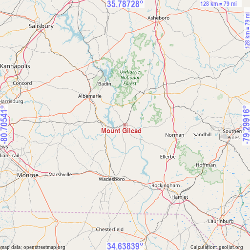
Mount Gilead GPS coordinates[2]
35° 12' 53.532" North, 80° 0' 8.208" West
| Map corner | latitude | longitude |
|---|---|---|
| Upper-left | 35.78728°, | -80.70541° |
| Center: | 35.21487°, | -80.00228° |
| Lower-right: | 34.63839°, | -79.29916° |
| Map W x H: | 127.7×127.7 km | = 79.3×79.3mi |
| max Lat: | 71.29058° ⇑74.2% North |
| Mount Gilead: | 35.21487° |
| min Lat: | ⇓25.8% South 19.06759° |
| min Long | Mount Gilead | max Long |
| -171.73463° | -80.00228° | -66.98998° |
| W 73.3%⇐ | ⇒26.7% E |
Elevation
Elevation of Mount Gilead is 123 m = 404 ft, and this is 171.8 m = 564 ft below average elevation for this country.
| Max E: |
3189 m = 10463 ft | 66% |
| Avg. | 294.8 m = 967 ft | |
| Mount Gilead | 123 m = 404 ft | |
Min E: |
-60 m = -197 ft | 34% |
See also: United States elevation on elevation.city.
Geographical zone
Mount Gilead is located in North temperate zone (between Tropic of Cancer and the Arctic Circle). Distance of this Northern Tropic circle is 1309.6 km =813.7 mi to South.| Distance of | km | miles | from Mount Gilead |
|---|---|---|---|
| North Pole | 6091.5 | 3785.1 | to North |
| Arctic Circle | 3485.6 | 2165.9 | to North |
| Tropic Cancer | 1309.6 | 813.7 | to South |
| Equator | 3915.5 | 2433 | to South |


Nearby cities:
15 places around Mount Gilead: (largest is in red/bold)
• Albemarle
23.4 km =14.5 mi,  309°
309°
• Ansonville
15.6 km =9.7 mi,  218°
218°
• Badin
23.6 km =14.7 mi,  333°
333°
• Biscoe
25.8 km =16 mi,  51°
51°
• Burnsville
24.8 km =15.4 mi,  242°
242°
• Candor
25 km =15.5 mi,  69°
69°
• Ellerbe
27.1 km =16.8 mi,  126°
126°
• Lilesville
27.5 km =17.1 mi,  176°
176°
• New London
32.1 km =19.9 mi,  322°
322°
• Norwood
10.6 km =6.6 mi,  272°
272°
• Oakboro
29.7 km =18.5 mi, 272°
• Polkton
29.3 km =18.2 mi, 218°
• Star
28.7 km =17.8 mi,  43°
43°
• Troy
18.7 km =11.6 mi,  31°
31°
• Wadesboro
28.3 km =17.6 mi,  193°
193°
Sources, notices
• [Note1] Compared only with cities in United States existing in our database
• [Src1] Map data: © OpenStreetMap contributors (CC-BY-SA)
• [Src2] Other city data from geonames.org with taken over terms of usage.
• [Src3] Geographical zone / Annual Mean Temperature by Robert A. Rohde @ Wikipedia
