Asheboro geodata
Asheboro (North Carolina) is a seat of a second-order administrative division; located in United States in America/New_York (GMT-4) time zone. With population of 26,103 people, there are 1922 cities with bigger population in this country. Compared to other cities in United States, 71.7% of cities are located further ↑North; 74.1% of cities are located further ←West and 63.7% of cities have lower elevation than Asheboro. Note1
Administrative division(s):
- Level 1: North Carolina
- Level 2: Randolph County
- Level 3: Township of Asheboro


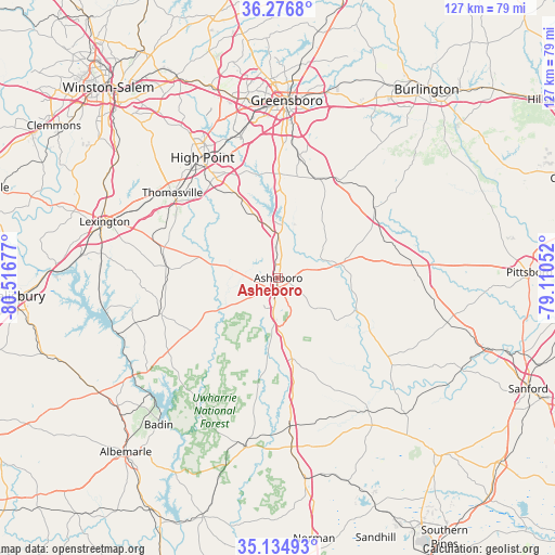
Asheboro GPS coordinates[2]
35° 42' 28.476" North, 79° 48' 49.104" West
| Map corner | latitude | longitude |
|---|---|---|
| Upper-left | 36.2768°, | -80.51677° |
| Center: | 35.70791°, | -79.81364° |
| Lower-right: | 35.13493°, | -79.11052° |
| Map W x H: | 127×127 km | = 78.9×78.9mi |
| max Lat: | 71.29058° ⇑71.7% North |
| Asheboro: | 35.70791° |
| min Lat: | ⇓28.3% South 19.06759° |
| min Long | Asheboro | max Long |
| -171.73463° | -79.81364° | -66.98998° |
| W 74.1%⇐ | ⇒25.9% E |
Elevation
Elevation of Asheboro is 256 m = 840 ft, and this is 38.8 m = 127 ft below average elevation for this country.
| Max E: |
3189 m = 10463 ft | 36.3% |
| Avg. | 294.8 m = 967 ft | |
| Asheboro | 256 m = 840 ft | |
Min E: |
-60 m = -197 ft | 63.7% |
See also: United States elevation on elevation.city.
Geographical zone
Asheboro is located in North temperate zone (between Tropic of Cancer and the Arctic Circle). Distance of this Northern Tropic circle is 1364.4 km =847.8 mi to South.| Distance of | km | miles | from Asheboro |
|---|---|---|---|
| North Pole | 6036.7 | 3751 | to North |
| Arctic Circle | 3430.8 | 2131.8 | to North |
| Tropic Cancer | 1364.4 | 847.8 | to South |
| Equator | 3970.3 | 2467 | to South |


Nearby cities:
15 places around Asheboro: (largest is in red/bold)
• Archdale
27.1 km =16.8 mi,  328°
328°
• Denton
28.5 km =17.7 mi,  253°
253°
• Forest Oaks
32.6 km =20.3 mi,  17°
17°
• Franklinville
11.7 km =7.3 mi,  70°
70°
• High Point
32.5 km =20.2 mi, 327°
• Jamestown
33.7 km =20.9 mi,  340°
340°
• Liberty
27.2 km =16.9 mi,  53°
53°
• Pleasant Garden
28.6 km =17.8 mi,  9°
9°
• Pleasant Hill
35.1 km =21.8 mi,  58°
58°
• Ramseur
14.8 km =9.2 mi,  78°
78°
• Randleman
12.3 km =7.6 mi,  4°
4°
• Siler City
31.8 km =19.8 mi,  86°
86°
• Star
34.1 km =21.2 mi,  175°
175°
• Thomasville
31 km =19.3 mi,  308°
308°
• Trinity
26.2 km =16.3 mi,  322°
322°
Sources, notices
• [Note1] Compared only with cities in United States existing in our database
• [Src1] Map data: © OpenStreetMap contributors (CC-BY-SA)
• [Src2] Other city data from geonames.org with taken over terms of usage.
• [Src3] Geographical zone / Annual Mean Temperature by Robert A. Rohde @ Wikipedia
