Ramseur geodata
Ramseur (North Carolina) is a populated place; located in United States in America/New_York (GMT-4) time zone. With population of 1,701 people, there are 12906 cities with bigger population in this country. Compared to other cities in United States, 71.6% of cities are located further ↑North; 74.6% of cities are located further ←West and 61.3% of cities have higher elevation than Ramseur. Note1
Administrative division(s):
- Level 1: North Carolina
- Level 2: Randolph County
- Level 3: Township of Columbia


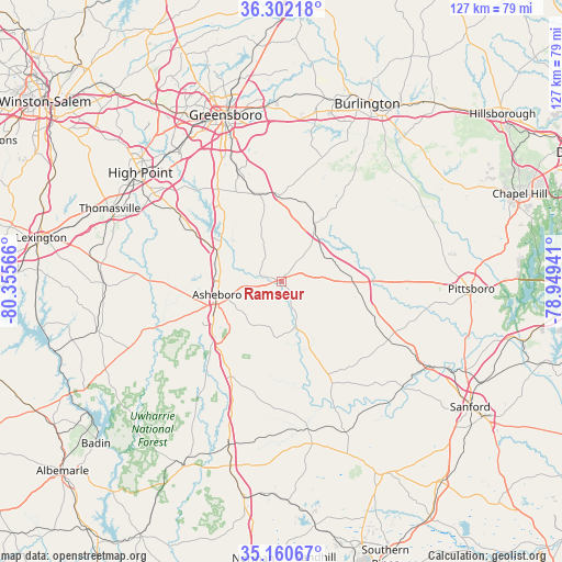
Ramseur GPS coordinates[2]
35° 44' 0.492" North, 79° 39' 9.108" West
| Map corner | latitude | longitude |
|---|---|---|
| Upper-left | 36.30218°, | -80.35566° |
| Center: | 35.73347°, | -79.65253° |
| Lower-right: | 35.16067°, | -78.94941° |
| Map W x H: | 126.9×126.9 km | = 78.9×78.9mi |
| max Lat: | 71.29058° ⇑71.6% North |
| Ramseur: | 35.73347° |
| min Lat: | ⇓28.4% South 19.06759° |
| min Long | Ramseur | max Long |
| -171.73463° | -79.65253° | -66.98998° |
| W 74.6%⇐ | ⇒25.4% E |
Elevation
Elevation of Ramseur is 148 m = 486 ft, and this is 146.8 m = 482 ft below average elevation for this country.
| Max E: |
3189 m = 10463 ft | 61.3% |
| Avg. | 294.8 m = 967 ft | |
| Ramseur | 148 m = 486 ft | |
Min E: |
-60 m = -197 ft | 38.7% |
See also: United States elevation on elevation.city.
Geographical zone
Ramseur is located in North temperate zone (between Tropic of Cancer and the Arctic Circle). Distance of this Northern Tropic circle is 1367.3 km =849.6 mi to South.| Distance of | km | miles | from Ramseur |
|---|---|---|---|
| North Pole | 6033.9 | 3749.3 | to North |
| Arctic Circle | 3428 | 2130.1 | to North |
| Tropic Cancer | 1367.3 | 849.6 | to South |
| Equator | 3973.2 | 2468.8 | to South |


Nearby cities:
15 places around Ramseur: (largest is in red/bold)
• Alamance
36.8 km =22.9 mi,  24°
24°
• Archdale
35.1 km =21.8 mi,  304°
304°
• Asheboro
14.8 km =9.2 mi,  258°
258°
• Forest Oaks
28.7 km =17.8 mi,  350°
350°
• Franklinville
3.8 km =2.4 mi,  287°
287°
• Liberty
15.2 km =9.4 mi,  28°
28°
• Pleasant Garden
27.3 km =17 mi,  338°
338°
• Pleasant Hill
21.9 km =13.6 mi,  44°
44°
• Randleman
16.5 km =10.3 mi, 304°
• Robbins
33.8 km =21 mi,  169°
169°
• Saxapahaw
38.1 km =23.7 mi,  51°
51°
• Sedalia
37.2 km =23.1 mi,  4°
4°
• Siler City
17.2 km =10.7 mi,  93°
93°
• Trinity
35.4 km =22 mi, 300°
• Whitsett
38.4 km =23.9 mi,  11°
11°
Sources, notices
• [Note1] Compared only with cities in United States existing in our database
• [Src1] Map data: © OpenStreetMap contributors (CC-BY-SA)
• [Src2] Other city data from geonames.org with taken over terms of usage.
• [Src3] Geographical zone / Annual Mean Temperature by Robert A. Rohde @ Wikipedia
