Denton geodata
Denton (North Carolina) is a populated place; located in United States in America/New_York (GMT-4) time zone. With population of 1,657 people, there are 13060 cities with bigger population in this country. Compared to other cities in United States, 72% of cities are located further ↑North; 72.7% of cities are located further ←West and 53.2% of cities have lower elevation than Denton. Note1
Administrative division(s):
- Level 1: North Carolina
- Level 2: Davidson County
- Level 3: Township of Emmons


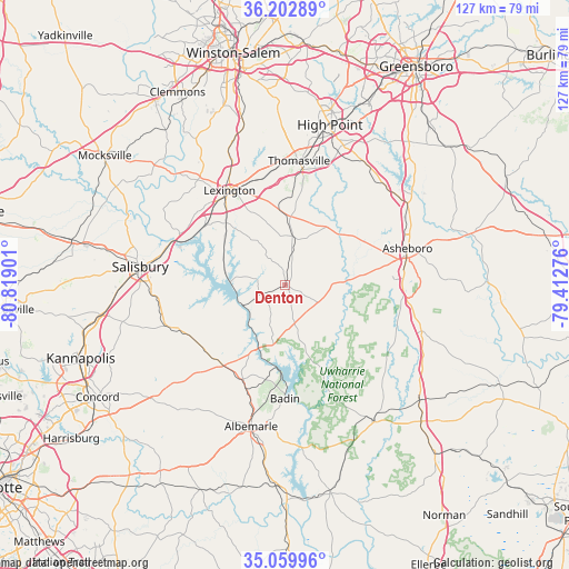
Denton GPS coordinates[2]
35° 38' 0.492" North, 80° 6' 57.168" West
| Map corner | latitude | longitude |
|---|---|---|
| Upper-left | 36.20289°, | -80.81901° |
| Center: | 35.63347°, | -80.11588° |
| Lower-right: | 35.05996°, | -79.41276° |
| Map W x H: | 127.1×127.1 km | = 79×79mi |
| max Lat: | 71.29058° ⇑72% North |
| Denton: | 35.63347° |
| min Lat: | ⇓28% South 19.06759° |
| min Long | Denton | max Long |
| -171.73463° | -80.11588° | -66.98998° |
| W 72.7%⇐ | ⇒27.3% E |
Elevation
Elevation of Denton is 211 m = 692 ft, and this is 83.8 m = 275 ft below average elevation for this country.
| Max E: |
3189 m = 10463 ft | 46.8% |
| Avg. | 294.8 m = 967 ft | |
| Denton | 211 m = 692 ft | |
Min E: |
-60 m = -197 ft | 53.2% |
See also: United States elevation on elevation.city.
Geographical zone
Denton is located in North temperate zone (between Tropic of Cancer and the Arctic Circle). Distance of this Northern Tropic circle is 1356.2 km =842.7 mi to South.| Distance of | km | miles | from Denton |
|---|---|---|---|
| North Pole | 6045 | 3756.2 | to North |
| Arctic Circle | 3439.1 | 2137 | to North |
| Tropic Cancer | 1356.2 | 842.7 | to South |
| Equator | 3962.1 | 2461.9 | to South |


Nearby cities:
15 places around Denton: (largest is in red/bold)
• Asheboro
28.5 km =17.7 mi,  73°
73°
• Badin
25.3 km =15.7 mi,  180°
180°
• East Spencer
29.1 km =18.1 mi,  280°
280°
• Faith
31.8 km =19.8 mi,  260°
260°
• Granite Quarry
30 km =18.6 mi,  265°
265°
• Lexington
24.6 km =15.3 mi,  329°
329°
• Misenheimer
22.7 km =14.1 mi,  223°
223°
• New London
23.1 km =14.4 mi,  203°
203°
• Richfield
22.2 km =13.8 mi, 215°
• Rockwell
27.8 km =17.3 mi,  250°
250°
• Southmont
14.2 km =8.8 mi,  285°
285°
• Spencer
29.5 km =18.3 mi, 282°
• Thomasville
27.9 km =17.3 mi,  6°
6°
• Trinity
31.1 km =19.3 mi,  21°
21°
• Tyro
30.3 km =18.8 mi,  310°
310°
Sources, notices
• [Note1] Compared only with cities in United States existing in our database
• [Src1] Map data: © OpenStreetMap contributors (CC-BY-SA)
• [Src2] Other city data from geonames.org with taken over terms of usage.
• [Src3] Geographical zone / Annual Mean Temperature by Robert A. Rohde @ Wikipedia
