Asheville geodata
Asheville (North Carolina) is a seat of a second-order administrative division; located in United States in America/New_York (GMT-4) time zone. With population of 88,512 people, there are 416 cities with bigger population in this country. Compared to other cities in United States, 72.2% of cities are located further ↑North; 63.6% of cities are located further ←West and 90.3% of cities have lower elevation than Asheville. Note1
Administrative division(s):
- Level 1: North Carolina
- Level 2: Buncombe County
- Level 3: City of Asheville


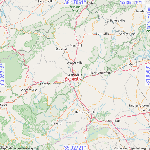
Asheville GPS coordinates[2]
35° 36' 3.42" North, 82° 33' 14.472" West
| Map corner | latitude | longitude |
|---|---|---|
| Upper-left | 36.17061°, | -83.25715° |
| Center: | 35.60095°, | -82.55402° |
| Lower-right: | 35.02721°, | -81.8509° |
| Map W x H: | 127.1×127.1 km | = 79×79mi |
| max Lat: | 71.29058° ⇑72.2% North |
| Asheville: | 35.60095° |
| min Lat: | ⇓27.8% South 19.06759° |
| min Long | Asheville | max Long |
| -171.73463° | -82.55402° | -66.98998° |
| W 63.6%⇐ | ⇒36.4% E |
Elevation
Elevation of Asheville is 650 m = 2133 ft, and this is 355.2 m = 1165 ft above average elevation for this country.
| Max E: |
3189 m = 10463 ft | 9.7% |
| Asheville | 650 m 2133 ft | |
| Avg. | 294.8 m = 967 ft | |
Min E: |
-60 m = -197 ft | 90.3% |
See also: Asheville elevation on elevation.city.
Geographical zone
Asheville is located in North temperate zone (between Tropic of Cancer and the Arctic Circle). Distance of this Northern Tropic circle is 1352.5 km =840.4 mi to South.| Distance of | km | miles | from Asheville |
|---|---|---|---|
| North Pole | 6048.6 | 3758.4 | to North |
| Arctic Circle | 3442.7 | 2139.2 | to North |
| Tropic Cancer | 1352.5 | 840.4 | to South |
| Equator | 3958.5 | 2459.7 | to South |


Nearby cities:
15 places around Asheville: (largest is in red/bold)
• Avery Creek
15.5 km =9.6 mi,  189°
189°
• Bent Creek
11.3 km =7 mi,  205°
205°
• Biltmore Forest
7.8 km =4.8 mi,  162°
162°
• Black Mountain
21.1 km =13.1 mi,  84°
84°
• Fairview
17.3 km =10.7 mi,  124°
124°
• Fletcher
19.5 km =12.1 mi,  165°
165°
• Hoopers Creek
19.7 km =12.2 mi, 156°
• Mars Hill
25.1 km =15.6 mi,  0°
0°
• Marshall
24.8 km =15.4 mi,  331°
331°
• Mills River
23.7 km =14.7 mi,  182°
182°
• Montreat
23.2 km =14.4 mi, 78°
• Royal Pines
14.4 km =8.9 mi, 166°
• Swannanoa
13.9 km =8.6 mi,  91°
91°
• Weaverville
10.7 km =6.6 mi,  356°
356°
• Woodfin
4.4 km =2.7 mi,  324°
324°
Sources, notices
• [Note1] Compared only with cities in United States existing in our database
• [Src1] Map data: © OpenStreetMap contributors (CC-BY-SA)
• [Src2] Other city data from geonames.org with taken over terms of usage.
• [Src3] Geographical zone / Annual Mean Temperature by Robert A. Rohde @ Wikipedia
