Marshall geodata
Marshall (North Carolina) is a seat of a second-order administrative division; located in United States in America/New_York (GMT-4) time zone. With population of 876 people, there are 17148 cities with bigger population in this country. Compared to other cities in United States, 71.3% of cities are located further ↑North; 63% of cities are located further ←West and 88% of cities have lower elevation than Marshall. Note1
Administrative division(s):
- Level 1: North Carolina
- Level 2: Madison County
- Level 3: Township 1, North Marshall


Marshall GPS coordinates[2]
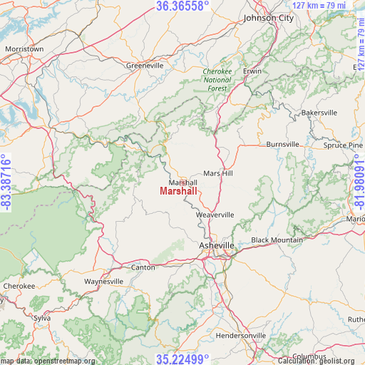
35° 47' 50.388" North, 82° 41' 2.508" West
| Map corner | latitude | longitude |
|---|---|---|
| Upper-left | 36.36558°, | -83.38716° |
| Center: | 35.79733°, | -82.68403° |
| Lower-right: | 35.22499°, | -81.98091° |
| Map W x H: | 126.8×126.8 km | = 78.8×78.8mi |
| max Lat: | 71.29058° ⇑71.3% North |
| Marshall: | 35.79733° |
| min Lat: | ⇓28.7% South 19.06759° |
| min Long | Marshall | max Long |
| -171.73463° | -82.68403° | -66.98998° |
| W 63%⇐ | ⇒37% E |
Elevation
Elevation of Marshall is 505 m = 1657 ft, and this is 210.2 m = 690 ft above average elevation for this country.
| Max E: |
3189 m = 10463 ft | 12% |
| Marshall | 505 m 1657 ft | |
| Avg. | 294.8 m = 967 ft | |
Min E: |
-60 m = -197 ft | 88% |
See also: United States elevation on elevation.city.
Geographical zone
Marshall is located in North temperate zone (between Tropic of Cancer and the Arctic Circle). Distance of this Northern Tropic circle is 1374.4 km =854 mi to South.| Distance of | km | miles | from Marshall |
|---|---|---|---|
| North Pole | 6026.8 | 3744.9 | to North |
| Arctic Circle | 3420.9 | 2125.6 | to North |
| Tropic Cancer | 1374.4 | 854 | to South |
| Equator | 3980.3 | 2473.2 | to South |


Nearby cities:
15 places around Marshall: (largest is in red/bold)
• Asheville
24.8 km =15.4 mi,  151°
151°
• Avery Creek
38.2 km =23.7 mi,  166°
166°
• Bent Creek
32.8 km =20.4 mi, 167°
• Biltmore Forest
32.5 km =20.2 mi, 154°
• Burnsville
37 km =23 mi,  68°
68°
• Canton
32.5 km =20.2 mi,  205°
205°
• Clyde
35.8 km =22.2 mi, 214°
• Cove Creek
36.4 km =22.6 mi,  234°
234°
• Hot Springs
17 km =10.6 mi,  308°
308°
• Mars Hill
12.6 km =7.8 mi,  75°
75°
• Montreat
38.4 km =23.9 mi,  116°
116°
• Swannanoa
33.9 km =21.1 mi,  130°
130°
• Weaverville
15.8 km =9.8 mi,  135°
135°
• West Canton
32.9 km =20.4 mi, 208°
• Woodfin
20.4 km =12.7 mi, 153°
Sources, notices
• [Note1] Compared only with cities in United States existing in our database
• [Src1] Map data: © OpenStreetMap contributors (CC-BY-SA)
• [Src2] Other city data from geonames.org with taken over terms of usage.
• [Src3] Geographical zone / Annual Mean Temperature by Robert A. Rohde @ Wikipedia
