Zebulon geodata
Zebulon (North Carolina) is a populated place; located in United States in America/New_York (GMT-4) time zone. With population of 4,964 people, there are 7216 cities with bigger population in this country. Compared to other cities in United States, 71.2% of cities are located further ↑North; 77.3% of cities are located further ←West and 70.3% of cities have higher elevation than Zebulon. Note1
Administrative division(s):
- Level 1: North Carolina
- Level 2: Wake County
- Level 3: Township of Little River


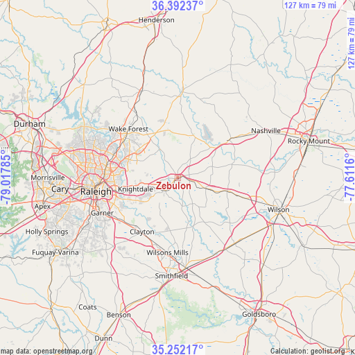
Zebulon GPS coordinates[2]
35° 49' 27.552" North, 78° 18' 52.992" West
| Map corner | latitude | longitude |
|---|---|---|
| Upper-left | 36.39237°, | -79.01785° |
| Center: | 35.82432°, | -78.31472° |
| Lower-right: | 35.25217°, | -77.6116° |
| Map W x H: | 126.8×126.8 km | = 78.8×78.8mi |
| max Lat: | 71.29058° ⇑71.2% North |
| Zebulon: | 35.82432° |
| min Lat: | ⇓28.8% South 19.06759° |
| min Long | Zebulon | max Long |
| -171.73463° | -78.31472° | -66.98998° |
| W 77.3%⇐ | ⇒22.7% E |
Elevation
Elevation of Zebulon is 99 m = 325 ft, and this is 195.8 m = 642 ft below average elevation for this country.
| Max E: |
3189 m = 10463 ft | 70.3% |
| Avg. | 294.8 m = 967 ft | |
| Zebulon | 99 m = 325 ft | |
Min E: |
-60 m = -197 ft | 29.7% |
See also: United States elevation on elevation.city.
Geographical zone
Zebulon is located in North temperate zone (between Tropic of Cancer and the Arctic Circle). Distance of this Northern Tropic circle is 1377.4 km =855.9 mi to South.| Distance of | km | miles | from Zebulon |
|---|---|---|---|
| North Pole | 6023.8 | 3743 | to North |
| Arctic Circle | 3417.9 | 2123.8 | to North |
| Tropic Cancer | 1377.4 | 855.9 | to South |
| Equator | 3983.3 | 2475.1 | to South |


Nearby cities:
15 places around Zebulon: (largest is in red/bold)
• Archer Lodge
15.5 km =9.6 mi,  200°
200°
• Bailey
18.3 km =11.4 mi,  105°
105°
• Clayton
23.2 km =14.4 mi,  213°
213°
• Garner
29.8 km =18.5 mi,  245°
245°
• Kenly
30.6 km =19 mi,  145°
145°
• Knightdale
15.5 km =9.6 mi, 254°
• Louisburg
30.6 km =19 mi,  2°
2°
• Middlesex
10.7 km =6.6 mi, 110°
• Raleigh
29.8 km =18.5 mi,  258°
258°
• Rolesville
16.9 km =10.5 mi,  310°
310°
• Spring Hope
22.7 km =14.1 mi,  53°
53°
• Wake Forest
24.6 km =15.3 mi, 314°
• Wendell
6.9 km =4.3 mi,  225°
225°
• Wilsons Mills
27 km =16.8 mi,  187°
187°
• Youngsville
26.5 km =16.5 mi,  327°
327°
Sources, notices
• [Note1] Compared only with cities in United States existing in our database
• [Src1] Map data: © OpenStreetMap contributors (CC-BY-SA)
• [Src2] Other city data from geonames.org with taken over terms of usage.
• [Src3] Geographical zone / Annual Mean Temperature by Robert A. Rohde @ Wikipedia
