Burgaw geodata
Burgaw (North Carolina) is a seat of a second-order administrative division; located in United States in America/New_York (GMT-4) time zone. With population of 4,100 people, there are 8093 cities with bigger population in this country. Compared to other cities in United States, 77.4% of cities are located further ↑North; 77.9% of cities are located further ←West and 91.5% of cities have higher elevation than Burgaw. Note1
Administrative division(s):
- Level 1: North Carolina
- Level 2: Pender County
- Level 3: Township of Burgaw


Burgaw GPS coordinates[2]
34° 33' 7.596" North, 77° 55' 33.96" West
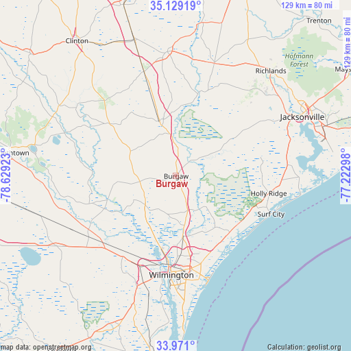
| Map corner | latitude | longitude |
|---|---|---|
| Upper-left | 35.12919°, | -78.62923° |
| Center: | 34.55211°, | -77.9261° |
| Lower-right: | 33.971°, | -77.22298° |
| Map W x H: | 128.8×128.8 km | = 80×80mi |
| max Lat: | 71.29058° ⇑77.4% North |
| Burgaw: | 34.55211° |
| min Lat: | ⇓22.6% South 19.06759° |
| min Long | Burgaw | max Long |
| -171.73463° | -77.9261° | -66.98998° |
| W 77.9%⇐ | ⇒22.1% E |
Elevation
Elevation of Burgaw is 13 m = 43 ft, and this is 281.8 m = 925 ft below average elevation for this country.
| Max E: |
3189 m = 10463 ft | 91.5% |
| Avg. | 294.8 m = 967 ft | |
| Burgaw | 13 m = 43 ft | |
Min E: |
-60 m = -197 ft | 8.5% |
See also: United States elevation on elevation.city.
Geographical zone
Burgaw is located in North temperate zone (between Tropic of Cancer and the Arctic Circle). Distance of this Northern Tropic circle is 1235.9 km =768 mi to South.| Distance of | km | miles | from Burgaw |
|---|---|---|---|
| North Pole | 6165.2 | 3830.9 | to North |
| Arctic Circle | 3559.3 | 2211.6 | to North |
| Tropic Cancer | 1235.9 | 768 | to South |
| Equator | 3841.8 | 2387.2 | to South |


Nearby cities:
15 places around Burgaw: (largest is in red/bold)
• Bayshore
31.8 km =19.8 mi,  156°
156°
• Castle Hayne
22 km =13.7 mi,  173°
173°
• Greenevers
30.1 km =18.7 mi,  359°
359°
• Hampstead
28.5 km =17.7 mi,  136°
136°
• Hightsville
31.4 km =19.5 mi,  180°
180°
• Kings Grant
32.7 km =20.3 mi, 169°
• Kirkland
30.7 km =19.1 mi, 155°
• Murraysville
29.4 km =18.3 mi, 165°
• Northchase
27.5 km =17.1 mi, 170°
• Ogden
32.6 km =20.3 mi, 162°
• Rocky Point
13.5 km =8.4 mi, 164°
• Rose Hill
32 km =19.9 mi,  343°
343°
• Skippers Corner
23 km =14.3 mi, 174°
• Wallace
21.4 km =13.3 mi, 342°
• Wrightsboro
29.3 km =18.2 mi, 179°
Sources, notices
• [Note1] Compared only with cities in United States existing in our database
• [Src1] Map data: © OpenStreetMap contributors (CC-BY-SA)
• [Src2] Other city data from geonames.org with taken over terms of usage.
• [Src3] Geographical zone / Annual Mean Temperature by Robert A. Rohde @ Wikipedia
