Pine Level geodata
Pine Level (North Carolina) is a populated place; located in United States in America/New_York (GMT-4) time zone. With population of 1,861 people, there are 12335 cities with bigger population in this country. Compared to other cities in United States, 72.6% of cities are located further ↑North; 77.4% of cities are located further ←West and 78.8% of cities have higher elevation than Pine Level. Note1
Administrative division(s):
- Level 1: North Carolina
- Level 2: Johnston County
- Level 3: Township of Pine Level


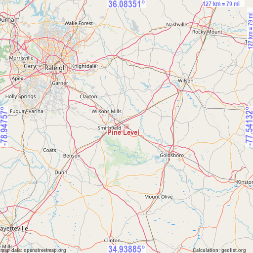
Pine Level GPS coordinates[2]
35° 30' 47.592" North, 78° 14' 39.984" West
| Map corner | latitude | longitude |
|---|---|---|
| Upper-left | 36.08351°, | -78.94757° |
| Center: | 35.51322°, | -78.24444° |
| Lower-right: | 34.93885°, | -77.54132° |
| Map W x H: | 127.3×127.3 km | = 79.1×79.1mi |
| max Lat: | 71.29058° ⇑72.6% North |
| Pine Level: | 35.51322° |
| min Lat: | ⇓27.4% South 19.06759° |
| min Long | Pine Level | max Long |
| -171.73463° | -78.24444° | -66.98998° |
| W 77.4%⇐ | ⇒22.6% E |
Elevation
Elevation of Pine Level is 52 m = 171 ft, and this is 242.8 m = 797 ft below average elevation for this country.
| Max E: |
3189 m = 10463 ft | 78.8% |
| Avg. | 294.8 m = 967 ft | |
| Pine Level | 52 m = 171 ft | |
Min E: |
-60 m = -197 ft | 21.2% |
See also: United States elevation on elevation.city.
Geographical zone
Pine Level is located in North temperate zone (between Tropic of Cancer and the Arctic Circle). Distance of this Northern Tropic circle is 1342.8 km =834.4 mi to South.| Distance of | km | miles | from Pine Level |
|---|---|---|---|
| North Pole | 6058.4 | 3764.5 | to North |
| Arctic Circle | 3452.5 | 2145.3 | to North |
| Tropic Cancer | 1342.8 | 834.4 | to South |
| Equator | 3948.7 | 2453.6 | to South |


Nearby cities:
15 places around Pine Level: (largest is in red/bold)
• Archer Lodge
23.3 km =14.5 mi,  329°
329°
• Brogden
31 km =19.3 mi,  142°
142°
• Clayton
24.5 km =15.2 mi,  308°
308°
• Four Oaks
18.2 km =11.3 mi,  245°
245°
• Fremont
24.7 km =15.3 mi,  81°
81°
• Goldsboro
26.9 km =16.7 mi,  122°
122°
• Kenly
14.3 km =8.9 mi,  49°
49°
• Lucama
25.8 km =16 mi,  55°
55°
• Mar-Mac
26.2 km =16.3 mi, 139°
• Middlesex
31 km =19.3 mi,  6°
6°
• Pikeville
23.8 km =14.8 mi,  94°
94°
• Princeton
9.2 km =5.7 mi, 124°
• Selma
4.5 km =2.8 mi, 305°
• Smithfield
8.6 km =5.3 mi,  266°
266°
• Wilsons Mills
12.8 km =8 mi, 308°
Sources, notices
• [Note1] Compared only with cities in United States existing in our database
• [Src1] Map data: © OpenStreetMap contributors (CC-BY-SA)
• [Src2] Other city data from geonames.org with taken over terms of usage.
• [Src3] Geographical zone / Annual Mean Temperature by Robert A. Rohde @ Wikipedia
