Mayodan geodata
Mayodan (North Carolina) is a populated place; located in United States in America/New_York (GMT-4) time zone. With population of 2,470 people, there are 10699 cities with bigger population in this country. Compared to other cities in United States, 68.4% of cities are located further ↑North; 73.4% of cities are located further ←West and 52.5% of cities have higher elevation than Mayodan. Note1
Administrative division(s):
- Level 1: North Carolina
- Level 2: Rockingham County
- Level 3: Township of Madison


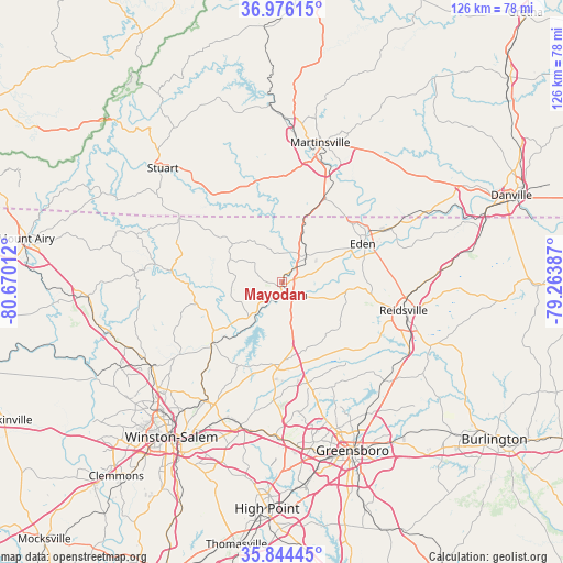
Mayodan GPS coordinates[2]
36° 24' 44.496" North, 79° 58' 1.164" West
| Map corner | latitude | longitude |
|---|---|---|
| Upper-left | 36.97615°, | -80.67012° |
| Center: | 36.41236°, | -79.96699° |
| Lower-right: | 35.84445°, | -79.26387° |
| Map W x H: | 125.8×125.8 km | = 78.2×78.2mi |
| max Lat: | 71.29058° ⇑68.4% North |
| Mayodan: | 36.41236° |
| min Lat: | ⇓31.6% South 19.06759° |
| min Long | Mayodan | max Long |
| -171.73463° | -79.96699° | -66.98998° |
| W 73.4%⇐ | ⇒26.6% E |
Elevation
Elevation of Mayodan is 189 m = 620 ft, and this is 105.8 m = 347 ft below average elevation for this country.
| Max E: |
3189 m = 10463 ft | 52.5% |
| Avg. | 294.8 m = 967 ft | |
| Mayodan | 189 m = 620 ft | |
Min E: |
-60 m = -197 ft | 47.5% |
See also: United States elevation on elevation.city.
Geographical zone
Mayodan is located in North temperate zone (between Tropic of Cancer and the Arctic Circle). Distance of this Northern Tropic circle is 1442.8 km =896.5 mi to South.| Distance of | km | miles | from Mayodan |
|---|---|---|---|
| North Pole | 5958.4 | 3702.4 | to North |
| Arctic Circle | 3352.5 | 2083.1 | to North |
| Tropic Cancer | 1442.8 | 896.5 | to South |
| Equator | 4048.7 | 2515.7 | to South |


Nearby cities:
15 places around Mayodan: (largest is in red/bold)
• Chatmoss
30.5 km =19 mi,  26°
26°
• Danbury
21.4 km =13.3 mi,  269°
269°
• Eden
19.8 km =12.3 mi,  64°
64°
• Germanton
28.9 km =18 mi,  234°
234°
• Horse Pasture
24.1 km =15 mi,  3°
3°
• Madison
3.1 km =1.9 mi,  167°
167°
• Oak Ridge
26.6 km =16.5 mi,  184°
184°
• Reidsville
27.8 km =17.3 mi,  103°
103°
• Ridgeway
20.7 km =12.9 mi, 27°
• Stokesdale
19.5 km =12.1 mi, 183°
• Stoneville
8.1 km =5 mi,  41°
41°
• Summerfield
23.3 km =14.5 mi, 166°
• Walkertown
31.2 km =19.4 mi,  212°
212°
• Walnut Cove
20.3 km =12.6 mi, 230°
• Wentworth
17.3 km =10.7 mi,  94°
94°
Sources, notices
• [Note1] Compared only with cities in United States existing in our database
• [Src1] Map data: © OpenStreetMap contributors (CC-BY-SA)
• [Src2] Other city data from geonames.org with taken over terms of usage.
• [Src3] Geographical zone / Annual Mean Temperature by Robert A. Rohde @ Wikipedia
