Huntersville geodata
Huntersville (North Carolina) is a populated place; located in United States in America/New_York (GMT-4) time zone. With population of 52,704 people, there are 885 cities with bigger population in this country. Compared to other cities in United States, 73.1% of cities are located further ↑North; 69.8% of cities are located further ←West and 61.9% of cities have lower elevation than Huntersville. Note1


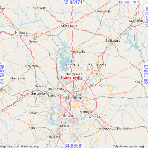
Huntersville GPS coordinates[2]
35° 24' 38.484" North, 80° 50' 34.26" West
| Map corner | latitude | longitude |
|---|---|---|
| Upper-left | 35.98171°, | -81.54598° |
| Center: | 35.41069°, | -80.84285° |
| Lower-right: | 34.8356°, | -80.13973° |
| Map W x H: | 127.4×127.4 km | = 79.2×79.2mi |
| max Lat: | 71.29058° ⇑73.1% North |
| Huntersville: | 35.41069° |
| min Lat: | ⇓26.9% South 19.06759° |
| min Long | Huntersville | max Long |
| -171.73463° | -80.84285° | -66.98998° |
| W 69.8%⇐ | ⇒30.2% E |
Elevation
Elevation of Huntersville is 248 m = 814 ft, and this is 46.8 m = 154 ft below average elevation for this country.
| Max E: |
3189 m = 10463 ft | 38.1% |
| Avg. | 294.8 m = 967 ft | |
| Huntersville | 248 m = 814 ft | |
Min E: |
-60 m = -197 ft | 61.9% |
See also: Huntersville elevation on elevation.city.
Geographical zone
Huntersville is located in North temperate zone (between Tropic of Cancer and the Arctic Circle). Distance of this Northern Tropic circle is 1331.4 km =827.3 mi to South.| Distance of | km | miles | from Huntersville |
|---|---|---|---|
| North Pole | 6069.8 | 3771.6 | to North |
| Arctic Circle | 3463.9 | 2152.4 | to North |
| Tropic Cancer | 1331.4 | 827.3 | to South |
| Equator | 3937.3 | 2446.5 | to South |


Nearby cities:
15 places around Huntersville: (largest is in red/bold)
• Belmont
25.7 km =16 mi,  223°
223°
• Charlotte
20.4 km =12.7 mi,  180°
180°
• Concord
23.7 km =14.7 mi,  90°
90°
• Cornelius
8.6 km =5.3 mi,  349°
349°
• Davidson
10.2 km =6.3 mi,  1°
1°
• Denver
21.6 km =13.4 mi,  308°
308°
• Enochville
20.6 km =12.8 mi,  50°
50°
• Harrisburg
19.3 km =12 mi,  119°
119°
• Kannapolis
21.8 km =13.5 mi,  66°
66°
• Lake Norman of Catawba
22.2 km =13.8 mi,  331°
331°
• Lowesville
15.3 km =9.5 mi,  272°
272°
• Mooresville
19.6 km =12.2 mi,  8°
8°
• Mount Holly
20.1 km =12.5 mi,  231°
231°
• Stanley
23.7 km =14.7 mi,  256°
256°
• Westport
15.9 km =9.9 mi, 309°
Sources, notices
• [Note1] Compared only with cities in United States existing in our database
• [Src1] Map data: © OpenStreetMap contributors (CC-BY-SA)
• [Src2] Other city data from geonames.org with taken over terms of usage.
• [Src3] Geographical zone / Annual Mean Temperature by Robert A. Rohde @ Wikipedia
