Newton Grove geodata
Newton Grove (North Carolina) is a populated place; located in United States in America/New_York (GMT-4) time zone. With population of 576 people, there are 19960 cities with bigger population in this country. Compared to other cities in United States, 74% of cities are located further ↑North; 77.2% of cities are located further ←West and 78.8% of cities have higher elevation than Newton Grove. Note1
Administrative division(s):
- Level 1: North Carolina
- Level 2: Sampson County
- Level 3: Township of Newton Grove


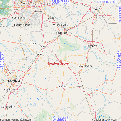
Newton Grove GPS coordinates[2]
35° 14' 42.576" North, 78° 21' 15.012" West
| Map corner | latitude | longitude |
|---|---|---|
| Upper-left | 35.81736°, | -79.0573° |
| Center: | 35.24516°, | -78.35417° |
| Lower-right: | 34.6689°, | -77.65105° |
| Map W x H: | 127.7×127.7 km | = 79.3×79.3mi |
| max Lat: | 71.29058° ⇑74% North |
| Newton Grove: | 35.24516° |
| min Lat: | ⇓26% South 19.06759° |
| min Long | Newton Grove | max Long |
| -171.73463° | -78.35417° | -66.98998° |
| W 77.2%⇐ | ⇒22.8% E |
Elevation
Elevation of Newton Grove is 52 m = 171 ft, and this is 242.8 m = 797 ft below average elevation for this country.
| Max E: |
3189 m = 10463 ft | 78.8% |
| Avg. | 294.8 m = 967 ft | |
| Newton Grove | 52 m = 171 ft | |
Min E: |
-60 m = -197 ft | 21.2% |
See also: United States elevation on elevation.city.
Geographical zone
Newton Grove is located in North temperate zone (between Tropic of Cancer and the Arctic Circle). Distance of this Northern Tropic circle is 1313 km =815.9 mi to South.| Distance of | km | miles | from Newton Grove |
|---|---|---|---|
| North Pole | 6088.2 | 3783 | to North |
| Arctic Circle | 3482.3 | 2163.8 | to North |
| Tropic Cancer | 1313 | 815.9 | to South |
| Equator | 3918.9 | 2435.1 | to South |


Nearby cities:
15 places around Newton Grove: (largest is in red/bold)
• Benson
23.3 km =14.5 mi,  310°
310°
• Brogden
29.5 km =18.3 mi,  79°
79°
• Calypso
24.8 km =15.4 mi,  114°
114°
• Clinton
27.6 km =17.1 mi,  174°
174°
• Dunn
24.1 km =15 mi,  286°
286°
• Erwin
30.6 km =19 mi, 287°
• Faison
24.5 km =15.2 mi,  125°
125°
• Four Oaks
23.2 km =14.4 mi,  343°
343°
• Keener
15.7 km =9.8 mi, 168°
• Mar-Mac
28.9 km =18 mi,  69°
69°
• Mount Olive
26.7 km =16.6 mi,  101°
101°
• Plain View
18.3 km =11.4 mi,  271°
271°
• Princeton
30.2 km =18.8 mi,  35°
35°
• Smithfield
29.3 km =18.2 mi,  2°
2°
• Spiveys Corner
13.3 km =8.3 mi,  245°
245°
Sources, notices
• [Note1] Compared only with cities in United States existing in our database
• [Src1] Map data: © OpenStreetMap contributors (CC-BY-SA)
• [Src2] Other city data from geonames.org with taken over terms of usage.
• [Src3] Geographical zone / Annual Mean Temperature by Robert A. Rohde @ Wikipedia
