Brogden geodata
Brogden (North Carolina) is a populated place; located in United States in America/New_York (GMT-4) time zone. With population of 2,633 people, there are 10323 cities with bigger population in this country. Compared to other cities in United States, 73.7% of cities are located further ↑North; 77.7% of cities are located further ←West and 78.2% of cities have higher elevation than Brogden. Note1
Administrative division(s):
- Level 1: North Carolina
- Level 2: Wayne County
- Level 3: Township of Brogden


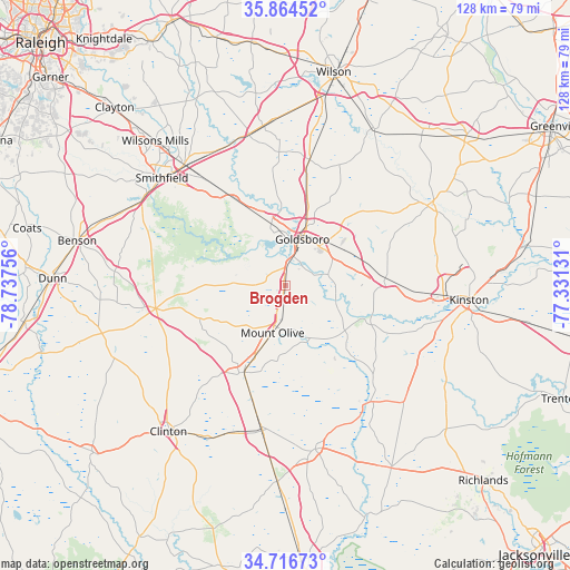
Brogden GPS coordinates[2]
35° 17' 33.576" North, 78° 2' 3.948" West
| Map corner | latitude | longitude |
|---|---|---|
| Upper-left | 35.86452°, | -78.73756° |
| Center: | 35.29266°, | -78.03443° |
| Lower-right: | 34.71673°, | -77.33131° |
| Map W x H: | 127.6×127.6 km | = 79.3×79.3mi |
| max Lat: | 71.29058° ⇑73.7% North |
| Brogden: | 35.29266° |
| min Lat: | ⇓26.3% South 19.06759° |
| min Long | Brogden | max Long |
| -171.73463° | -78.03443° | -66.98998° |
| W 77.7%⇐ | ⇒22.3% E |
Elevation
Elevation of Brogden is 55 m = 180 ft, and this is 239.8 m = 787 ft below average elevation for this country.
| Max E: |
3189 m = 10463 ft | 78.2% |
| Avg. | 294.8 m = 967 ft | |
| Brogden | 55 m = 180 ft | |
Min E: |
-60 m = -197 ft | 21.8% |
See also: United States elevation on elevation.city.
Geographical zone
Brogden is located in North temperate zone (between Tropic of Cancer and the Arctic Circle). Distance of this Northern Tropic circle is 1318.3 km =819.2 mi to South.| Distance of | km | miles | from Brogden |
|---|---|---|---|
| North Pole | 6082.9 | 3779.7 | to North |
| Arctic Circle | 3477 | 2160.5 | to North |
| Tropic Cancer | 1318.3 | 819.2 | to South |
| Equator | 3924.2 | 2438.4 | to South |


Nearby cities:
15 places around Brogden: (largest is in red/bold)
• Calypso
16.7 km =10.4 mi,  202°
202°
• Elroy
12.7 km =7.9 mi,  64°
64°
• Faison
21.7 km =13.5 mi,  205°
205°
• Fremont
28.6 km =17.8 mi,  10°
10°
• Goldsboro
10.9 km =6.8 mi,  20°
20°
• Keener
33.1 km =20.6 mi,  231°
231°
• La Grange
22.4 km =13.9 mi,  85°
85°
• Mar-Mac
5.1 km =3.2 mi,  337°
337°
• Mount Olive
11.1 km =6.9 mi, 195°
• Newton Grove
29.5 km =18.3 mi,  259°
259°
• Pikeville
23.2 km =14.4 mi, 11°
• Pine Level
31 km =19.3 mi,  322°
322°
• Princeton
22.4 km =13.9 mi,  329°
329°
• Walnut Creek
15.5 km =9.6 mi,  84°
84°
• Warsaw
33 km =20.5 mi,  188°
188°
Sources, notices
• [Note1] Compared only with cities in United States existing in our database
• [Src1] Map data: © OpenStreetMap contributors (CC-BY-SA)
• [Src2] Other city data from geonames.org with taken over terms of usage.
• [Src3] Geographical zone / Annual Mean Temperature by Robert A. Rohde @ Wikipedia
