Robbins geodata
Robbins (North Carolina) is a populated place; located in United States in America/New_York (GMT-4) time zone. With population of 1,184 people, there are 15208 cities with bigger population in this country. Compared to other cities in United States, 73% of cities are located further ↑North; 74.7% of cities are located further ←West and 64.2% of cities have higher elevation than Robbins. Note1


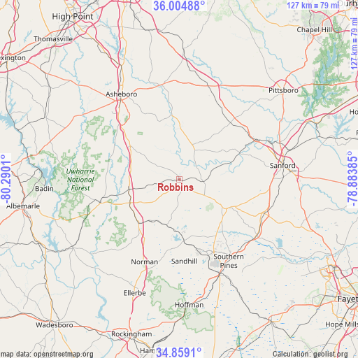
Robbins GPS coordinates[2]
35° 26' 2.508" North, 79° 35' 13.092" West
| Map corner | latitude | longitude |
|---|---|---|
| Upper-left | 36.00488°, | -80.2901° |
| Center: | 35.43403°, | -79.58697° |
| Lower-right: | 34.8591°, | -78.88385° |
| Map W x H: | 127.4×127.4 km | = 79.2×79.2mi |
| max Lat: | 71.29058° ⇑73% North |
| Robbins: | 35.43403° |
| min Lat: | ⇓27% South 19.06759° |
| min Long | Robbins | max Long |
| -171.73463° | -79.58697° | -66.98998° |
| W 74.7%⇐ | ⇒25.3% E |
Elevation
Elevation of Robbins is 132 m = 433 ft, and this is 162.8 m = 534 ft below average elevation for this country.
| Max E: |
3189 m = 10463 ft | 64.2% |
| Avg. | 294.8 m = 967 ft | |
| Robbins | 132 m = 433 ft | |
Min E: |
-60 m = -197 ft | 35.8% |
See also: United States elevation on elevation.city.
Geographical zone
Robbins is located in North temperate zone (between Tropic of Cancer and the Arctic Circle). Distance of this Northern Tropic circle is 1334 km =828.9 mi to South.| Distance of | km | miles | from Robbins |
|---|---|---|---|
| North Pole | 6067.2 | 3770 | to North |
| Arctic Circle | 3461.3 | 2150.8 | to North |
| Tropic Cancer | 1334 | 828.9 | to South |
| Equator | 3939.9 | 2448.1 | to South |


Nearby cities:
15 places around Robbins: (largest is in red/bold)
• Biscoe
19.3 km =12 mi,  244°
244°
• Candor
21.1 km =13.1 mi,  222°
222°
• Carthage
18.3 km =11.4 mi,  122°
122°
• Foxfire
28.8 km =17.9 mi,  177°
177°
• Franklinville
35.7 km =22.2 mi,  344°
344°
• Pinehurst
28.6 km =17.8 mi,  158°
158°
• Ramseur
33.8 km =21 mi,  349°
349°
• Seven Lakes
17.4 km =10.8 mi,  173°
173°
• Siler City
34.1 km =21.2 mi,  19°
19°
• Southern Pines
33.9 km =21.1 mi,  148°
148°
• Star
18.2 km =11.3 mi,  258°
258°
• Taylortown
26.8 km =16.7 mi, 159°
• Troy
29.1 km =18.1 mi,  253°
253°
• Vass
34 km =21.1 mi,  125°
125°
• Whispering Pines
27.8 km =17.3 mi,  135°
135°
Sources, notices
• [Note1] Compared only with cities in United States existing in our database
• [Src1] Map data: © OpenStreetMap contributors (CC-BY-SA)
• [Src2] Other city data from geonames.org with taken over terms of usage.
• [Src3] Geographical zone / Annual Mean Temperature by Robert A. Rohde @ Wikipedia
