Riegelwood geodata
Riegelwood (North Carolina) is a populated place; located in United States in America/New_York (GMT-4) time zone. With population of 579 people, there are 19929 cities with bigger population in this country. Compared to other cities in United States, 78.3% of cities are located further ↑North; 77.4% of cities are located further ←West and 93% of cities have higher elevation than Riegelwood. Note1
Administrative division(s):
- Level 1: North Carolina
- Level 2: Columbus County
- Level 3: Township of Ransom


Riegelwood GPS coordinates[2]
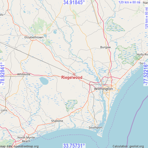
34° 20' 23.604" North, 78° 13' 31.008" West
| Map corner | latitude | longitude |
|---|---|---|
| Upper-left | 34.91845°, | -78.92841° |
| Center: | 34.33989°, | -78.22528° |
| Lower-right: | 33.75731°, | -77.52216° |
| Map W x H: | 129.1×129.1 km | = 80.2×80.2mi |
| max Lat: | 71.29058° ⇑78.3% North |
| Riegelwood: | 34.33989° |
| min Lat: | ⇓21.7% South 19.06759° |
| min Long | Riegelwood | max Long |
| -171.73463° | -78.22528° | -66.98998° |
| W 77.4%⇐ | ⇒22.6% E |
Elevation
Elevation of Riegelwood is 11 m = 36 ft, and this is 283.8 m = 931 ft below average elevation for this country.
| Max E: |
3189 m = 10463 ft | 93% |
| Avg. | 294.8 m = 967 ft | |
| Riegelwood | 11 m = 36 ft | |
Min E: |
-60 m = -197 ft | 7% |
See also: United States elevation on elevation.city.
Geographical zone
Riegelwood is located in North temperate zone (between Tropic of Cancer and the Arctic Circle). Distance of this Northern Tropic circle is 1212.3 km =753.3 mi to South.| Distance of | km | miles | from Riegelwood |
|---|---|---|---|
| North Pole | 6188.8 | 3845.5 | to North |
| Arctic Circle | 3582.9 | 2226.3 | to North |
| Tropic Cancer | 1212.3 | 753.3 | to South |
| Equator | 3818.2 | 2372.5 | to South |


Nearby cities:
15 places around Riegelwood: (largest is in red/bold)
• Belville
26.7 km =16.6 mi,  116°
116°
• Bolivia
31.1 km =19.3 mi,  166°
166°
• Bolton
16.4 km =10.2 mi,  262°
262°
• Castle Hayne
29.9 km =18.6 mi,  86°
86°
• Hightsville
28.1 km =17.5 mi,  106°
106°
• Kelly
16.7 km =10.4 mi,  327°
327°
• Lake Waccamaw
25.3 km =15.7 mi, 264°
• Leland
19 km =11.8 mi, 119°
• Navassa
22.1 km =13.7 mi, 115°
• Northchase
32.1 km =19.9 mi,  96°
96°
• Northwest
6.6 km =4.1 mi, 116°
• Rocky Point
32.7 km =20.3 mi,  71°
71°
• Skippers Corner
29.6 km =18.4 mi, 88°
• Wilmington
28.7 km =17.8 mi, 116°
• Wrightsboro
28.5 km =17.7 mi, 101°
Sources, notices
• [Note1] Compared only with cities in United States existing in our database
• [Src1] Map data: © OpenStreetMap contributors (CC-BY-SA)
• [Src2] Other city data from geonames.org with taken over terms of usage.
• [Src3] Geographical zone / Annual Mean Temperature by Robert A. Rohde @ Wikipedia
