Kelly geodata
Kelly (North Carolina) is a populated place; located in United States in America/New_York (GMT-4) time zone. With population of 544 people, there are 20345 cities with bigger population in this country. Compared to other cities in United States, 77.8% of cities are located further ↑North; 77.2% of cities are located further ←West and 95.7% of cities have higher elevation than Kelly. Note1
Administrative division(s):
- Level 1: North Carolina
- Level 2: Bladen County
- Level 3: Township of Frenches Creek


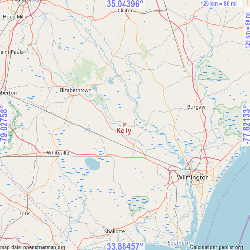
Kelly GPS coordinates[2]
34° 27' 58.608" North, 78° 19' 28.02" West
| Map corner | latitude | longitude |
|---|---|---|
| Upper-left | 35.04396°, | -79.02758° |
| Center: | 34.46628°, | -78.32445° |
| Lower-right: | 33.88457°, | -77.62133° |
| Map W x H: | 128.9×128.9 km | = 80.1×80.1mi |
| max Lat: | 71.29058° ⇑77.8% North |
| Kelly: | 34.46628° |
| min Lat: | ⇓22.2% South 19.06759° |
| min Long | Kelly | max Long |
| -171.73463° | -78.32445° | -66.98998° |
| W 77.2%⇐ | ⇒22.8% E |
Elevation
Elevation of Kelly is 8 m = 26 ft, and this is 286.8 m = 941 ft below average elevation for this country.
| Max E: |
3189 m = 10463 ft | 95.7% |
| Avg. | 294.8 m = 967 ft | |
| Kelly | 8 m = 26 ft | |
Min E: |
-60 m = -197 ft | 4.3% |
See also: United States elevation on elevation.city.
Geographical zone
Kelly is located in North temperate zone (between Tropic of Cancer and the Arctic Circle). Distance of this Northern Tropic circle is 1226.4 km =762 mi to South.| Distance of | km | miles | from Kelly |
|---|---|---|---|
| North Pole | 6174.8 | 3836.8 | to North |
| Arctic Circle | 3568.9 | 2217.6 | to North |
| Tropic Cancer | 1226.4 | 762 | to South |
| Equator | 3832.3 | 2381.3 | to South |


Nearby cities:
15 places around Kelly: (largest is in red/bold)
• Bolton
17.7 km =11 mi,  203°
203°
• Brunswick
39.9 km =24.8 mi,  240°
240°
• Burgaw
37.7 km =23.4 mi,  75°
75°
• Castle Hayne
40.8 km =25.4 mi,  107°
107°
• Clarkton
30.5 km =19 mi,  274°
274°
• Elizabethtown
31.5 km =19.6 mi,  305°
305°
• Garland
36.1 km =22.4 mi,  349°
349°
• Lake Waccamaw
23 km =14.3 mi,  224°
224°
• Leland
34.7 km =21.6 mi,  132°
132°
• Navassa
37.4 km =23.2 mi, 128°
• Northwest
22.7 km =14.1 mi,  138°
138°
• Riegelwood
16.7 km =10.4 mi,  147°
147°
• Rocky Point
40.2 km =25 mi,  94°
94°
• White Lake
24.3 km =15.1 mi,  322°
322°
• Whiteville
37.5 km =23.3 mi,  247°
247°
Sources, notices
• [Note1] Compared only with cities in United States existing in our database
• [Src1] Map data: © OpenStreetMap contributors (CC-BY-SA)
• [Src2] Other city data from geonames.org with taken over terms of usage.
• [Src3] Geographical zone / Annual Mean Temperature by Robert A. Rohde @ Wikipedia
