Roseboro geodata
Roseboro (North Carolina) is a populated place; located in United States in America/New_York (GMT-4) time zone. With population of 1,203 people, there are 15117 cities with bigger population in this country. Compared to other cities in United States, 75.7% of cities are located further ↑North; 76.9% of cities are located further ←West and 80.9% of cities have higher elevation than Roseboro. Note1
Administrative division(s):
- Level 1: North Carolina
- Level 2: Sampson County
- Level 3: Township of Little Coharie


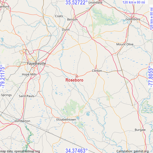
Roseboro GPS coordinates[2]
34° 57' 10.62" North, 78° 30' 31.032" West
| Map corner | latitude | longitude |
|---|---|---|
| Upper-left | 35.52722°, | -79.21175° |
| Center: | 34.95295°, | -78.50862° |
| Lower-right: | 34.37463°, | -77.8055° |
| Map W x H: | 128.2×128.2 km | = 79.7×79.7mi |
| max Lat: | 71.29058° ⇑75.7% North |
| Roseboro: | 34.95295° |
| min Lat: | ⇓24.3% South 19.06759° |
| min Long | Roseboro | max Long |
| -171.73463° | -78.50862° | -66.98998° |
| W 76.9%⇐ | ⇒23.1% E |
Elevation
Elevation of Roseboro is 43 m = 141 ft, and this is 251.8 m = 826 ft below average elevation for this country.
| Max E: |
3189 m = 10463 ft | 80.9% |
| Avg. | 294.8 m = 967 ft | |
| Roseboro | 43 m = 141 ft | |
Min E: |
-60 m = -197 ft | 19.1% |
See also: United States elevation on elevation.city.
Geographical zone
Roseboro is located in North temperate zone (between Tropic of Cancer and the Arctic Circle). Distance of this Northern Tropic circle is 1280.5 km =795.7 mi to South.| Distance of | km | miles | from Roseboro |
|---|---|---|---|
| North Pole | 6120.7 | 3803.2 | to North |
| Arctic Circle | 3514.8 | 2184 | to North |
| Tropic Cancer | 1280.5 | 795.7 | to South |
| Equator | 3886.4 | 2414.9 | to South |


Nearby cities:
15 places around Roseboro: (largest is in red/bold)
• Clinton
17.6 km =10.9 mi,  73°
73°
• Eastover
31.2 km =19.4 mi,  301°
301°
• Elizabethtown
37 km =23 mi,  193°
193°
• Faison
38.5 km =23.9 mi,  61°
61°
• Fayetteville
35.5 km =22.1 mi,  288°
288°
• Garland
21.3 km =13.2 mi,  150°
150°
• Keener
24.4 km =15.2 mi,  45°
45°
• Newton Grove
35.4 km =22 mi,  23°
23°
• Plain View
33.1 km =20.6 mi,  352°
352°
• Spiveys Corner
27 km =16.8 mi,  4°
4°
• Stedman
18.2 km =11.3 mi, 291°
• Vander
27.5 km =17.1 mi, 288°
• Wade
31.2 km =19.4 mi,  318°
318°
• Warsaw
38.4 km =23.9 mi,  82°
82°
• White Lake
34.8 km =21.6 mi,  176°
176°
Sources, notices
• [Note1] Compared only with cities in United States existing in our database
• [Src1] Map data: © OpenStreetMap contributors (CC-BY-SA)
• [Src2] Other city data from geonames.org with taken over terms of usage.
• [Src3] Geographical zone / Annual Mean Temperature by Robert A. Rohde @ Wikipedia
