Elizabethtown geodata
Elizabethtown (North Carolina) is a seat of a second-order administrative division; located in United States in America/New_York (GMT-4) time zone. With population of 3,586 people, there are 8739 cities with bigger population in this country. Compared to other cities in United States, 77.1% of cities are located further ↑North; 76.7% of cities are located further ←West and 82.6% of cities have higher elevation than Elizabethtown. Note1
Administrative division(s):
- Level 1: North Carolina
- Level 2: Bladen County
- Level 3: Township of Elizabethtown


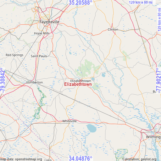
Elizabethtown GPS coordinates[2]
34° 37' 45.624" North, 78° 36' 19.044" West
| Map corner | latitude | longitude |
|---|---|---|
| Upper-left | 35.20588°, | -79.30842° |
| Center: | 34.62934°, | -78.60529° |
| Lower-right: | 34.04876°, | -77.90217° |
| Map W x H: | 128.7×128.7 km | = 80×80mi |
| max Lat: | 71.29058° ⇑77.1% North |
| Elizabethtown: | 34.62934° |
| min Lat: | ⇓22.9% South 19.06759° |
| min Long | Elizabethtown | max Long |
| -171.73463° | -78.60529° | -66.98998° |
| W 76.7%⇐ | ⇒23.3% E |
Elevation
Elevation of Elizabethtown is 36 m = 118 ft, and this is 258.8 m = 849 ft below average elevation for this country.
| Max E: |
3189 m = 10463 ft | 82.6% |
| Avg. | 294.8 m = 967 ft | |
| Elizabethtown | 36 m = 118 ft | |
Min E: |
-60 m = -197 ft | 17.4% |
See also: United States elevation on elevation.city.
Geographical zone
Elizabethtown is located in North temperate zone (between Tropic of Cancer and the Arctic Circle). Distance of this Northern Tropic circle is 1244.5 km =773.3 mi to South.| Distance of | km | miles | from Elizabethtown |
|---|---|---|---|
| North Pole | 6156.6 | 3825.5 | to North |
| Arctic Circle | 3550.8 | 2206.4 | to North |
| Tropic Cancer | 1244.5 | 773.3 | to South |
| Equator | 3850.4 | 2392.5 | to South |


Nearby cities:
15 places around Elizabethtown: (largest is in red/bold)
• Barker Ten Mile
35.5 km =22.1 mi,  279°
279°
• Bladenboro
19.5 km =12.1 mi,  238°
238°
• Bolton
39.1 km =24.3 mi,  151°
151°
• Brunswick
39.1 km =24.3 mi,  192°
192°
• Chadbourn
39.7 km =24.7 mi,  210°
210°
• Clarkton
16.5 km =10.3 mi,  196°
196°
• Garland
26 km =16.2 mi,  47°
47°
• Kelly
31.5 km =19.6 mi,  125°
125°
• Lake Waccamaw
35.8 km =22.2 mi,  164°
164°
• Lumberton
37.1 km =23.1 mi,  268°
268°
• Roseboro
37 km =23 mi,  13°
13°
• Saint Pauls
38.8 km =24.1 mi,  300°
300°
• Stedman
43.5 km =27 mi,  349°
349°
• White Lake
11.2 km =7 mi,  83°
83°
• Whiteville
33.5 km =20.8 mi, 195°
Sources, notices
• [Note1] Compared only with cities in United States existing in our database
• [Src1] Map data: © OpenStreetMap contributors (CC-BY-SA)
• [Src2] Other city data from geonames.org with taken over terms of usage.
• [Src3] Geographical zone / Annual Mean Temperature by Robert A. Rohde @ Wikipedia
