Grifton geodata
Grifton (North Carolina) is a populated place; located in United States in America/New_York (GMT-4) time zone. With population of 2,673 people, there are 10230 cities with bigger population in this country. Compared to other cities in United States, 73.3% of cities are located further ↑North; 79.1% of cities are located further ←West and 98.1% of cities have higher elevation than Grifton. Note1
Administrative division(s):
- Level 1: North Carolina
- Level 2: Pitt County
- Level 3: Township of Grifton


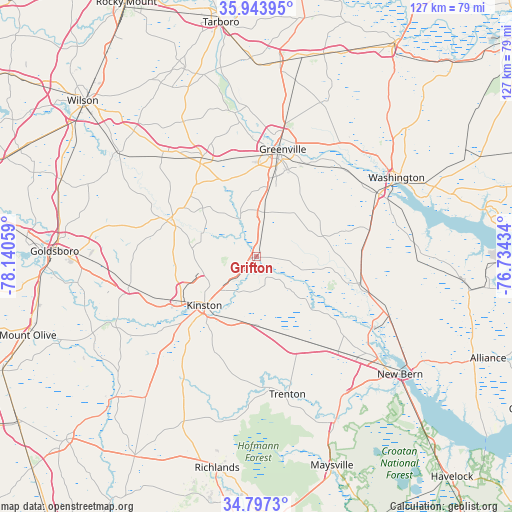
Grifton GPS coordinates[2]
35° 22' 21.576" North, 77° 26' 14.856" West
| Map corner | latitude | longitude |
|---|---|---|
| Upper-left | 35.94395°, | -78.14059° |
| Center: | 35.37266°, | -77.43746° |
| Lower-right: | 34.7973°, | -76.73434° |
| Map W x H: | 127.5×127.5 km | = 79.2×79.2mi |
| max Lat: | 71.29058° ⇑73.3% North |
| Grifton: | 35.37266° |
| min Lat: | ⇓26.7% South 19.06759° |
| min Long | Grifton | max Long |
| -171.73463° | -77.43746° | -66.98998° |
| W 79.1%⇐ | ⇒20.9% E |
Elevation
Elevation of Grifton is 5 m = 16 ft, and this is 289.8 m = 951 ft below average elevation for this country.
| Max E: |
3189 m = 10463 ft | 98.1% |
| Avg. | 294.8 m = 967 ft | |
| Grifton | 5 m = 16 ft | |
Min E: |
-60 m = -197 ft | 1.9% |
See also: United States elevation on elevation.city.
Geographical zone
Grifton is located in North temperate zone (between Tropic of Cancer and the Arctic Circle). Distance of this Northern Tropic circle is 1327.2 km =824.7 mi to South.| Distance of | km | miles | from Grifton |
|---|---|---|---|
| North Pole | 6074 | 3774.2 | to North |
| Arctic Circle | 3468.1 | 2155 | to North |
| Tropic Cancer | 1327.2 | 824.7 | to South |
| Equator | 3933.1 | 2443.9 | to South |


Nearby cities:
15 places around Grifton: (largest is in red/bold)
• Ayden
11.3 km =7 mi,  10°
10°
• Chocowinity
34.3 km =21.3 mi,  62°
62°
• Farmville
28.2 km =17.5 mi,  331°
331°
• Greenville
27.5 km =17.1 mi, 13°
• Kinston
17.9 km =11.1 mi,  226°
226°
• La Grange
32.6 km =20.3 mi,  257°
257°
• Maury
18.1 km =11.2 mi,  312°
312°
• River Bend
42.9 km =26.7 mi,  141°
141°
• Snow Hill
23.8 km =14.8 mi,  291°
291°
• Trenton
34.8 km =21.6 mi,  167°
167°
• Vanceboro
26.7 km =16.6 mi,  105°
105°
• Walnut Creek
39.5 km =24.5 mi, 259°
• Washington
39.9 km =24.8 mi, 61°
• Windsor
21.2 km =13.2 mi,  19°
19°
• Winterville
17.7 km =11 mi, 10°
Sources, notices
• [Note1] Compared only with cities in United States existing in our database
• [Src1] Map data: © OpenStreetMap contributors (CC-BY-SA)
• [Src2] Other city data from geonames.org with taken over terms of usage.
• [Src3] Geographical zone / Annual Mean Temperature by Robert A. Rohde @ Wikipedia
