Camden geodata
Camden (New Jersey) is a seat of a second-order administrative division; located in United States in America/New_York (GMT-4) time zone. With population of 76,119 people, there are 528 cities with bigger population in this country. Compared to other cities in United States, 52.7% of cities are located further ↓South; 87% of cities are located further ←West and 98.8% of cities have higher elevation than Camden. Note1


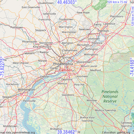
Camden GPS coordinates[2]
39° 55' 33.42" North, 75° 7' 10.632" West
| Map corner | latitude | longitude |
|---|---|---|
| Upper-left | 40.46303°, | -75.82275° |
| Center: | 39.92595°, | -75.11962° |
| Lower-right: | 39.38462°, | -74.4165° |
| Map W x H: | 119.9×119.9 km | = 74.5×74.5mi |
| max Lat: | 71.29058° ⇑47.3% North |
| Camden: | 39.92595° |
| min Lat: | ⇓52.7% South 19.06759° |
| min Long | Camden | max Long |
| -171.73463° | -75.11962° | -66.98998° |
| W 87%⇐ | ⇒13% E |
Elevation
Elevation of Camden is 4 m = 13 ft, and this is 290.8 m = 954 ft below average elevation for this country.
| Max E: |
3189 m = 10463 ft | 98.8% |
| Avg. | 294.8 m = 967 ft | |
| Camden | 4 m = 13 ft | |
Min E: |
-60 m = -197 ft | 1.2% |
See also: Camden elevation on elevation.city.
Geographical zone
Camden is located in North temperate zone (between Tropic of Cancer and the Arctic Circle). Distance of this Northern Tropic circle is 1833.4 km =1139.2 mi to South.| Distance of | km | miles | from Camden |
|---|---|---|---|
| North Pole | 5567.7 | 3459.6 | to North |
| Arctic Circle | 2961.8 | 1840.4 | to North |
| Tropic Cancer | 1833.4 | 1139.2 | to South |
| Equator | 4439.3 | 2758.5 | to South |


Nearby cities:
15 places around Camden: (largest is in red/bold)
• Audubon
5.6 km =3.5 mi,  134°
134°
• Audubon Park
4.3 km =2.7 mi,  140°
140°
• Brooklawn
5.3 km =3.3 mi,  181°
181°
• Center City
4.4 km =2.7 mi,  309°
309°
• Collingswood
4.2 km =2.6 mi,  101°
101°
• Gloucester City
3.8 km =2.4 mi, 175°
• Merchantville
5.1 km =3.2 mi,  62°
62°
• Mount Ephraim
5.8 km =3.6 mi,  156°
156°
• Oaklyn
4.1 km =2.5 mi, 132°
• Pennsauken
6.2 km =3.9 mi, 57°
• Pennsport
2.6 km =1.6 mi,  274°
274°
• Philadelphia
4.8 km =3 mi, 307°
• Wharton
3.2 km =2 mi, 271°
• Whitman
3.2 km =2 mi,  251°
251°
• Wood-Lynne
2.2 km =1.4 mi,  115°
115°
Sources, notices
• [Note1] Compared only with cities in United States existing in our database
• [Src1] Map data: © OpenStreetMap contributors (CC-BY-SA)
• [Src2] Other city data from geonames.org with taken over terms of usage.
• [Src3] Geographical zone / Annual Mean Temperature by Robert A. Rohde @ Wikipedia
