Philadelphia geodata
Philadelphia (Pennsylvania) is a seat of a second-order administrative division; located in United States in America/New_York (GMT-4) time zone. With population of 1,567,442 people, there are 6 cities with bigger population in this country. Compared to other cities in United States, 53% of cities are located further ↓South; 86.8% of cities are located further ←West and 81.6% of cities have higher elevation than Philadelphia. Note1
Administrative division(s):
- Level 1: Pennsylvania
- Level 2: Philadelphia County
- Level 3: City of Philadelphia


Philadelphia GPS coordinates[2]
39° 57' 8.388" North, 75° 9' 49.644" West
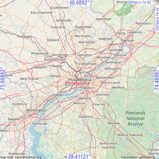
| Map corner | latitude | longitude |
|---|---|---|
| Upper-left | 40.4892°, | -75.86692° |
| Center: | 39.95233°, | -75.16379° |
| Lower-right: | 39.41121°, | -74.46067° |
| Map W x H: | 119.9×119.9 km | = 74.5×74.5mi |
| max Lat: | 71.29058° ⇑47% North |
| Philadelphia: | 39.95233° |
| min Lat: | ⇓53% South 19.06759° |
| min Long | Philadelphia | max Long |
| -171.73463° | -75.16379° | -66.98998° |
| W 86.8%⇐ | ⇒13.2% E |
Elevation
Elevation of Philadelphia is 40 m = 131 ft, and this is 254.8 m = 836 ft below average elevation for this country.
| Max E: |
3189 m = 10463 ft | 81.6% |
| Avg. | 294.8 m = 967 ft | |
| Philadelphia | 40 m = 131 ft | |
Min E: |
-60 m = -197 ft | 18.4% |
See also: Philadelphia elevation on elevation.city.
Geographical zone
Philadelphia is located in North temperate zone (between Tropic of Cancer and the Arctic Circle). Distance of this Northern Tropic circle is 1836.4 km =1141.1 mi to South.| Distance of | km | miles | from Philadelphia |
|---|---|---|---|
| North Pole | 5564.8 | 3457.8 | to North |
| Arctic Circle | 2958.9 | 1838.6 | to North |
| Tropic Cancer | 1836.4 | 1141.1 | to South |
| Equator | 4442.3 | 2760.3 | to South |


Nearby cities:
15 places around Philadelphia: (largest is in red/bold)
• Bala-Cynwyd
8.6 km =5.3 mi,  315°
315°
• Camden
4.8 km =3 mi,  127°
127°
• Center City
0.4 km =0.2 mi,  107°
107°
• Collingswood
8.8 km =5.5 mi,  115°
115°
• East Lansdowne
8.3 km =5.2 mi,  264°
264°
• Gloucester City
7.9 km =4.9 mi,  148°
148°
• Merchantville
8.3 km =5.2 mi,  93°
93°
• Millbourne
7.5 km =4.7 mi,  279°
279°
• Oaklyn
8.8 km =5.5 mi, 130°
• Pennsport
3 km =1.9 mi,  157°
157°
• Tioga
6.3 km =3.9 mi,  356°
356°
• Wharton
2.9 km =1.8 mi,  168°
168°
• Whitman
4 km =2.5 mi, 169°
• Wood-Lynne
6.9 km =4.3 mi, 124°
• Yeadon
8 km =5 mi, 259°
In other languages:
- In Spanish: Filadelfia
- In France: Philadelphie
- In Italian: Filadelfia
- In Russian: Филадельфия
- In Chinese: 費城
Sources, notices
• [Note1] Compared only with cities in United States existing in our database
• [Src1] Map data: © OpenStreetMap contributors (CC-BY-SA)
• [Src2] Other city data from geonames.org with taken over terms of usage.
• [Src3] Geographical zone / Annual Mean Temperature by Robert A. Rohde @ Wikipedia
