Olivet geodata
Olivet (New Jersey) is a populated place; located in United States in America/New_York (GMT-4) time zone. With population of 1,408 people, there are 14072 cities with bigger population in this country. Compared to other cities in United States, 50.5% of cities are located further ↑North; 86.9% of cities are located further ←West and 83.2% of cities have higher elevation than Olivet. Note1
Administrative division(s):
- Level 1: New Jersey
- Level 2: Salem County
- Level 3: Township of Pittsgrove


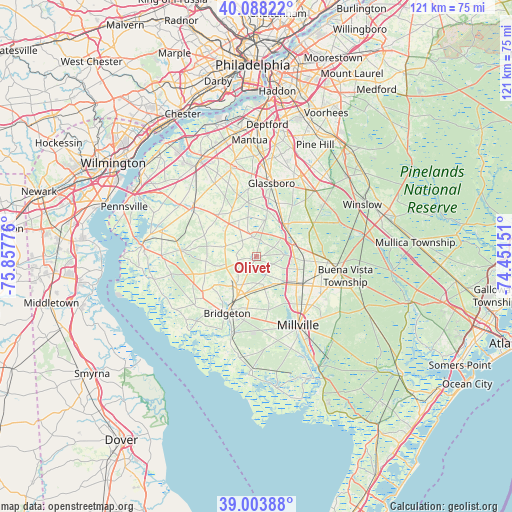
Olivet GPS coordinates[2]
39° 32' 53.412" North, 75° 9' 16.668" West
| Map corner | latitude | longitude |
|---|---|---|
| Upper-left | 40.08822°, | -75.85776° |
| Center: | 39.54817°, | -75.15463° |
| Lower-right: | 39.00388°, | -74.45151° |
| Map W x H: | 120.6×120.6 km | = 74.9×74.9mi |
| max Lat: | 71.29058° ⇑50.5% North |
| Olivet: | 39.54817° |
| min Lat: | ⇓49.5% South 19.06759° |
| min Long | Olivet | max Long |
| -171.73463° | -75.15463° | -66.98998° |
| W 86.9%⇐ | ⇒13.1% E |
Elevation
Elevation of Olivet is 34 m = 112 ft, and this is 260.8 m = 856 ft below average elevation for this country.
| Max E: |
3189 m = 10463 ft | 83.2% |
| Avg. | 294.8 m = 967 ft | |
| Olivet | 34 m = 112 ft | |
Min E: |
-60 m = -197 ft | 16.8% |
See also: United States elevation on elevation.city.
Geographical zone
Olivet is located in North temperate zone (between Tropic of Cancer and the Arctic Circle). Distance of this Northern Tropic circle is 1791.4 km =1113.1 mi to South.| Distance of | km | miles | from Olivet |
|---|---|---|---|
| North Pole | 5609.7 | 3485.7 | to North |
| Arctic Circle | 3003.8 | 1866.5 | to North |
| Tropic Cancer | 1791.4 | 1113.1 | to South |
| Equator | 4397.3 | 2732.4 | to South |


Nearby cities:
15 places around Olivet: (largest is in red/bold)
• Alloway
17.9 km =11.1 mi,  274°
274°
• Bridgeton
15.1 km =9.4 mi,  206°
206°
• Clayton
13.5 km =8.4 mi,  23°
23°
• Elmer
5.4 km =3.4 mi,  345°
345°
• Fairton
19.3 km =12 mi,  196°
196°
• Glassboro
17.6 km =10.9 mi,  12°
12°
• Millville
19 km =11.8 mi,  148°
148°
• Newfield
11 km =6.8 mi,  90°
90°
• Rosenhayn
8 km =5 mi,  165°
165°
• Seabrook Farms
7.6 km =4.7 mi,  225°
225°
• Shiloh
15.9 km =9.9 mi, 231°
• South Vineland
15.7 km =9.8 mi,  136°
136°
• Victory Lakes
18.7 km =11.6 mi,  59°
59°
• Vineland
13 km =8.1 mi,  121°
121°
• Woodstown
18.8 km =11.7 mi,  307°
307°
Sources, notices
• [Note1] Compared only with cities in United States existing in our database
• [Src1] Map data: © OpenStreetMap contributors (CC-BY-SA)
• [Src2] Other city data from geonames.org with taken over terms of usage.
• [Src3] Geographical zone / Annual Mean Temperature by Robert A. Rohde @ Wikipedia
