Vineland geodata
Vineland (New Jersey) is a populated place; located in United States in America/New_York (GMT-4) time zone. With population of 60,818 people, there are 725 cities with bigger population in this country. Compared to other cities in United States, 50.9% of cities are located further ↑North; 87.2% of cities are located further ←West and 83.2% of cities have higher elevation than Vineland. Note1
Administrative division(s):
- Level 1: New Jersey
- Level 2: Cumberland County
- Level 3: City of Vineland


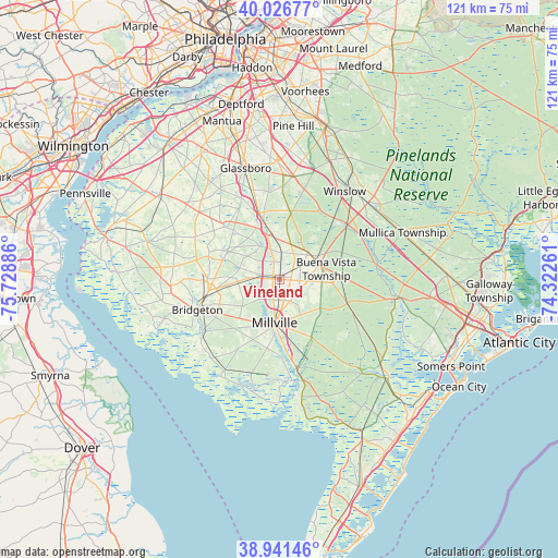
Vineland GPS coordinates[2]
39° 29' 10.428" North, 75° 1' 32.628" West
| Map corner | latitude | longitude |
|---|---|---|
| Upper-left | 40.02677°, | -75.72886° |
| Center: | 39.48623°, | -75.02573° |
| Lower-right: | 38.94146°, | -74.32261° |
| Map W x H: | 120.7×120.7 km | = 75×75mi |
| max Lat: | 71.29058° ⇑50.9% North |
| Vineland: | 39.48623° |
| min Lat: | ⇓49.1% South 19.06759° |
| min Long | Vineland | max Long |
| -171.73463° | -75.02573° | -66.98998° |
| W 87.2%⇐ | ⇒12.8% E |
Elevation
Elevation of Vineland is 34 m = 112 ft, and this is 260.8 m = 856 ft below average elevation for this country.
| Max E: |
3189 m = 10463 ft | 83.2% |
| Avg. | 294.8 m = 967 ft | |
| Vineland | 34 m = 112 ft | |
Min E: |
-60 m = -197 ft | 16.8% |
See also: Vineland elevation on elevation.city.
Geographical zone
Vineland is located in North temperate zone (between Tropic of Cancer and the Arctic Circle). Distance of this Northern Tropic circle is 1784.5 km =1108.8 mi to South.| Distance of | km | miles | from Vineland |
|---|---|---|---|
| North Pole | 5616.6 | 3490 | to North |
| Arctic Circle | 3010.7 | 1870.8 | to North |
| Tropic Cancer | 1784.5 | 1108.8 | to South |
| Equator | 4390.5 | 2728.1 | to South |


Nearby cities:
15 places around Vineland: (largest is in red/bold)
• Bridgeton
19 km =11.8 mi,  249°
249°
• Buena
9.2 km =5.7 mi,  70°
70°
• Clayton
20.2 km =12.6 mi,  343°
343°
• Collings Lakes
17.3 km =10.7 mi,  45°
45°
• Elmer
17.3 km =10.7 mi,  314°
314°
• Fairton
20.3 km =12.6 mi,  235°
235°
• Folsom
20.3 km =12.6 mi, 50°
• Laurel Lake
16.3 km =10.1 mi,  181°
181°
• Millville
9.4 km =5.8 mi,  187°
187°
• Newfield
6.7 km =4.2 mi,  359°
359°
• Olivet
13 km =8.1 mi,  301°
301°
• Rosenhayn
9.1 km =5.7 mi,  264°
264°
• Seabrook Farms
16.6 km =10.3 mi,  275°
275°
• South Vineland
4.5 km =2.8 mi, 183°
• Victory Lakes
17.1 km =10.6 mi,  17°
17°
Sources, notices
• [Note1] Compared only with cities in United States existing in our database
• [Src1] Map data: © OpenStreetMap contributors (CC-BY-SA)
• [Src2] Other city data from geonames.org with taken over terms of usage.
• [Src3] Geographical zone / Annual Mean Temperature by Robert A. Rohde @ Wikipedia
