Nelsonville geodata
Nelsonville (Ohio) is a populated place; located in United States in America/New_York (GMT-4) time zone. With population of 5,197 people, there are 7004 cities with bigger population in this country. Compared to other cities in United States, 51.1% of cities are located further ↑North; 64.8% of cities are located further ←West and 52.8% of cities have lower elevation than Nelsonville. Note1


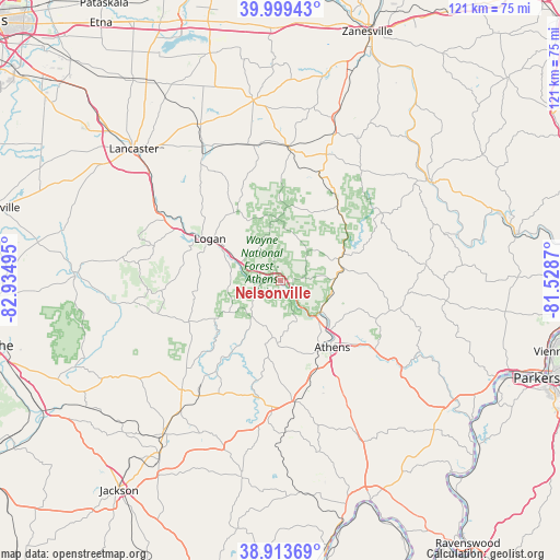
Nelsonville GPS coordinates[2]
39° 27' 31.248" North, 82° 13' 54.552" West
| Map corner | latitude | longitude |
|---|---|---|
| Upper-left | 39.99943°, | -82.93495° |
| Center: | 39.45868°, | -82.23182° |
| Lower-right: | 38.91369°, | -81.5287° |
| Map W x H: | 120.7×120.7 km | = 75×75mi |
| max Lat: | 71.29058° ⇑51.1% North |
| Nelsonville: | 39.45868° |
| min Lat: | ⇓48.9% South 19.06759° |
| min Long | Nelsonville | max Long |
| -171.73463° | -82.23182° | -66.98998° |
| W 64.8%⇐ | ⇒35.2% E |
Elevation
Elevation of Nelsonville is 209 m = 686 ft, and this is 85.8 m = 281 ft below average elevation for this country.
| Max E: |
3189 m = 10463 ft | 47.2% |
| Avg. | 294.8 m = 967 ft | |
| Nelsonville | 209 m = 686 ft | |
Min E: |
-60 m = -197 ft | 52.8% |
See also: United States elevation on elevation.city.
Geographical zone
Nelsonville is located in North temperate zone (between Tropic of Cancer and the Arctic Circle). Distance of this Northern Tropic circle is 1781.5 km =1107 mi to South.| Distance of | km | miles | from Nelsonville |
|---|---|---|---|
| North Pole | 5619.7 | 3491.9 | to North |
| Arctic Circle | 3013.8 | 1872.7 | to North |
| Tropic Cancer | 1781.5 | 1107 | to South |
| Equator | 4387.4 | 2726.2 | to South |


Nearby cities:
15 places around Nelsonville: (largest is in red/bold)
• Albany
25.8 km =16 mi,  174°
174°
• Athens
18.2 km =11.3 mi,  142°
142°
• Buchtel
4.3 km =2.7 mi,  85°
85°
• Chauncey
11.1 km =6.9 mi,  127°
127°
• Corning
20.2 km =12.6 mi,  37°
37°
• Geneva
28.5 km =17.7 mi,  322°
322°
• Glouster
13.6 km =8.5 mi,  68°
68°
• Hide-A-Way Hills
30.3 km =18.8 mi, 316°
• Junction City
29.7 km =18.5 mi,  348°
348°
• Logan
17.6 km =10.9 mi,  301°
301°
• McArthur
31.7 km =19.7 mi,  221°
221°
• New Lexington
28.5 km =17.7 mi,  4°
4°
• New Straitsville
13.3 km =8.3 mi,  357°
357°
• Shawnee
16.3 km =10.1 mi,  6°
6°
• The Plains
13.1 km =8.1 mi, 139°
Sources, notices
• [Note1] Compared only with cities in United States existing in our database
• [Src1] Map data: © OpenStreetMap contributors (CC-BY-SA)
• [Src2] Other city data from geonames.org with taken over terms of usage.
• [Src3] Geographical zone / Annual Mean Temperature by Robert A. Rohde @ Wikipedia
