London geodata
London (Ohio) is a seat of a second-order administrative division; located in United States in America/New_York (GMT-4) time zone. With population of 10,060 people, there are 4445 cities with bigger population in this country. Compared to other cities in United States, 52.3% of cities are located further ↓South; 60.7% of cities are located further ←West and 76.2% of cities have lower elevation than London. Note1


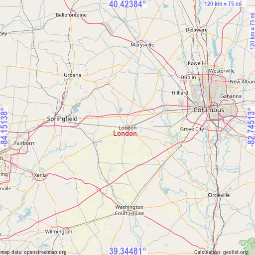
London GPS coordinates[2]
39° 53' 11.22" North, 83° 26' 53.7" West
| Map corner | latitude | longitude |
|---|---|---|
| Upper-left | 40.42384°, | -84.15138° |
| Center: | 39.88645°, | -83.44825° |
| Lower-right: | 39.34481°, | -82.74513° |
| Map W x H: | 120×120 km | = 74.6×74.6mi |
| max Lat: | 71.29058° ⇑47.7% North |
| London: | 39.88645° |
| min Lat: | ⇓52.3% South 19.06759° |
| min Long | London | max Long |
| -171.73463° | -83.44825° | -66.98998° |
| W 60.7%⇐ | ⇒39.3% E |
Elevation
Elevation of London is 321 m = 1053 ft, and this is 26.2 m = 86 ft above average elevation for this country.
| Max E: |
3189 m = 10463 ft | 23.8% |
| London | 321 m 1053 ft | |
| Avg. | 294.8 m = 967 ft | |
Min E: |
-60 m = -197 ft | 76.2% |
See also: United States elevation on elevation.city.
Geographical zone
London is located in North temperate zone (between Tropic of Cancer and the Arctic Circle). Distance of this Northern Tropic circle is 1829 km =1136.5 mi to South.| Distance of | km | miles | from London |
|---|---|---|---|
| North Pole | 5572.1 | 3462.3 | to North |
| Arctic Circle | 2966.2 | 1843.1 | to North |
| Tropic Cancer | 1829 | 1136.5 | to South |
| Equator | 4435 | 2755.8 | to South |


Nearby cities:
15 places around London: (largest is in red/bold)
• Bethel
18 km =11.2 mi,  164°
164°
• Choctaw Lake
8.8 km =5.5 mi,  339°
339°
• Darbydale
22.9 km =14.2 mi,  99°
99°
• Grove City
30.3 km =18.8 mi,  91°
91°
• Hilliard
29.6 km =18.4 mi,  56°
56°
• Jeffersonville
27.7 km =17.2 mi,  200°
200°
• Lake Darby
20.3 km =12.6 mi,  67°
67°
• Lincoln Village
28.1 km =17.5 mi, 74°
• Lisbon
16.2 km =10.1 mi,  259°
259°
• Mechanicsburg
22.6 km =14 mi, 335°
• Mount Sterling
24.3 km =15.1 mi,  139°
139°
• Northridge
30.5 km =19 mi,  292°
292°
• Plain City
29 km =18 mi,  32°
32°
• South Charleston
17.3 km =10.7 mi,  246°
246°
• West Jefferson
16.6 km =10.3 mi, 67°
Sources, notices
• [Note1] Compared only with cities in United States existing in our database
• [Src1] Map data: © OpenStreetMap contributors (CC-BY-SA)
• [Src2] Other city data from geonames.org with taken over terms of usage.
• [Src3] Geographical zone / Annual Mean Temperature by Robert A. Rohde @ Wikipedia
