Mount Orab geodata
Mount Orab (Ohio) is a populated place; located in United States in America/New_York (GMT-4) time zone. With population of 3,660 people, there are 8642 cities with bigger population in this country. Compared to other cities in United States, 54.6% of cities are located further ↑North; 59.5% of cities are located further ←West and 70.3% of cities have lower elevation than Mount Orab. Note1


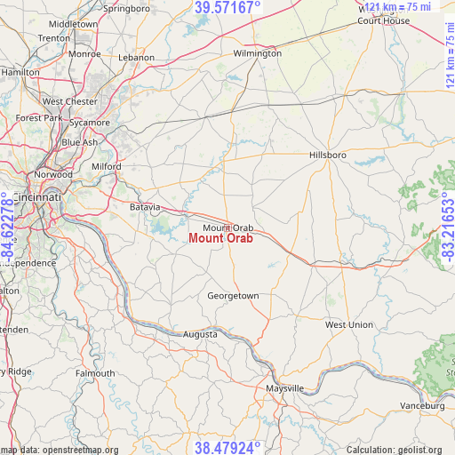
Mount Orab GPS coordinates[2]
39° 1' 39.252" North, 83° 55' 10.74" West
| Map corner | latitude | longitude |
|---|---|---|
| Upper-left | 39.57167°, | -84.62278° |
| Center: | 39.02757°, | -83.91965° |
| Lower-right: | 38.47924°, | -83.21653° |
| Map W x H: | 121.5×121.5 km | = 75.5×75.5mi |
| max Lat: | 71.29058° ⇑54.6% North |
| Mount Orab: | 39.02757° |
| min Lat: | ⇓45.4% South 19.06759° |
| min Long | Mount Orab | max Long |
| -171.73463° | -83.91965° | -66.98998° |
| W 59.5%⇐ | ⇒40.5% E |
Elevation
Elevation of Mount Orab is 287 m = 942 ft, and this is 7.8 m = 26 ft below average elevation for this country.
| Max E: |
3189 m = 10463 ft | 29.7% |
| Avg. | 294.8 m = 967 ft | |
| Mount Orab | 287 m = 942 ft | |
Min E: |
-60 m = -197 ft | 70.3% |
See also: United States elevation on elevation.city.
Geographical zone
Mount Orab is located in North temperate zone (between Tropic of Cancer and the Arctic Circle). Distance of this Northern Tropic circle is 1733.5 km =1077.1 mi to South.| Distance of | km | miles | from Mount Orab |
|---|---|---|---|
| North Pole | 5667.6 | 3521.7 | to North |
| Arctic Circle | 3061.7 | 1902.5 | to North |
| Tropic Cancer | 1733.5 | 1077.1 | to South |
| Equator | 4339.5 | 2696.4 | to South |


Nearby cities:
15 places around Mount Orab: (largest is in red/bold)
• Amelia
25.7 km =16 mi,  270°
270°
• Augusta
29.4 km =18.3 mi,  194°
194°
• Batavia
22.9 km =14.2 mi,  283°
283°
• Bethel
15.6 km =9.7 mi,  242°
242°
• Blanchester
30.1 km =18.7 mi,  348°
348°
• Felicity
25.9 km =16.1 mi,  216°
216°
• Georgetown
18.2 km =11.3 mi,  175°
175°
• Goshen
31 km =19.3 mi,  317°
317°
• Hamersville
13.4 km =8.3 mi,  204°
204°
• Lynchburg
26.3 km =16.3 mi,  24°
24°
• Owensville
21.4 km =13.3 mi,  299°
299°
• Russellville
21.3 km =13.2 mi,  147°
147°
• Sardinia
9.8 km =6.1 mi,  102°
102°
• Williamsburg
11.9 km =7.4 mi, 284°
• Winchester
25.1 km =15.6 mi,  112°
112°
Sources, notices
• [Note1] Compared only with cities in United States existing in our database
• [Src1] Map data: © OpenStreetMap contributors (CC-BY-SA)
• [Src2] Other city data from geonames.org with taken over terms of usage.
• [Src3] Geographical zone / Annual Mean Temperature by Robert A. Rohde @ Wikipedia
