Augusta geodata
Augusta (Kentucky) is a populated place; located in United States in America/New_York (GMT-4) time zone. With population of 1,163 people, there are 15318 cities with bigger population in this country. Compared to other cities in United States, 56.8% of cities are located further ↑North; 59.3% of cities are located further ←West and 59% of cities have higher elevation than Augusta. Note1


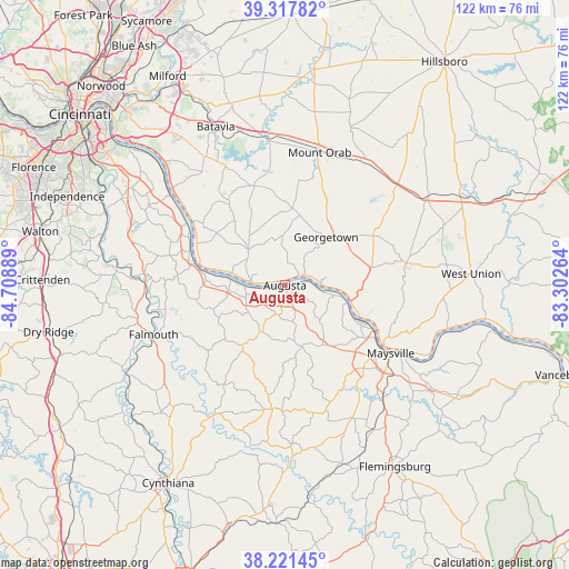
Augusta GPS coordinates[2]
38° 46' 18.264" North, 84° 0' 20.736" West
| Map corner | latitude | longitude |
|---|---|---|
| Upper-left | 39.31782°, | -84.70889° |
| Center: | 38.77174°, | -84.00576° |
| Lower-right: | 38.22145°, | -83.30264° |
| Map W x H: | 121.9×121.9 km | = 75.7×75.7mi |
| max Lat: | 71.29058° ⇑56.8% North |
| Augusta: | 38.77174° |
| min Lat: | ⇓43.2% South 19.06759° |
| min Long | Augusta | max Long |
| -171.73463° | -84.00576° | -66.98998° |
| W 59.3%⇐ | ⇒40.7% E |
Elevation
Elevation of Augusta is 160 m = 525 ft, and this is 134.8 m = 442 ft below average elevation for this country.
| Max E: |
3189 m = 10463 ft | 59% |
| Avg. | 294.8 m = 967 ft | |
| Augusta | 160 m = 525 ft | |
Min E: |
-60 m = -197 ft | 41% |
See also: United States elevation on elevation.city.
Geographical zone
Augusta is located in North temperate zone (between Tropic of Cancer and the Arctic Circle). Distance of this Northern Tropic circle is 1705.1 km =1059.5 mi to South.| Distance of | km | miles | from Augusta |
|---|---|---|---|
| North Pole | 5696 | 3539.3 | to North |
| Arctic Circle | 3090.2 | 1920.2 | to North |
| Tropic Cancer | 1705.1 | 1059.5 | to South |
| Equator | 4311 | 2678.7 | to South |


Nearby cities:
15 places around Augusta: (largest is in red/bold)
• Aberdeen
24.8 km =15.4 mi,  121°
121°
• Bethel
22.3 km =13.9 mi,  343°
343°
• Brooksville
11.2 km =7 mi,  207°
207°
• Falmouth
30.1 km =18.7 mi,  249°
249°
• Felicity
10.8 km =6.7 mi,  313°
313°
• Georgetown
13.6 km =8.5 mi,  40°
40°
• Hamersville
16.4 km =10.2 mi,  6°
6°
• Maysville
26.9 km =16.7 mi, 122°
• Mount Olivet
26.9 km =16.7 mi,  185°
185°
• Mount Orab
29.4 km =18.3 mi, 14°
• New Richmond
30.8 km =19.1 mi, 309°
• Old Washington
24.4 km =15.2 mi,  135°
135°
• Ripley
14.2 km =8.8 mi,  101°
101°
• Russellville
21.7 km =13.5 mi,  60°
60°
• Sardinia
31.3 km =19.4 mi,  33°
33°
Sources, notices
• [Note1] Compared only with cities in United States existing in our database
• [Src1] Map data: © OpenStreetMap contributors (CC-BY-SA)
• [Src2] Other city data from geonames.org with taken over terms of usage.
• [Src3] Geographical zone / Annual Mean Temperature by Robert A. Rohde @ Wikipedia
