Hamersville geodata
Hamersville (Ohio) is a populated place; located in United States in America/New_York (GMT-4) time zone. With population of 533 people, there are 20466 cities with bigger population in this country. Compared to other cities in United States, 55.7% of cities are located further ↑North; 59.3% of cities are located further ←West and 71.8% of cities have lower elevation than Hamersville. Note1


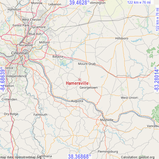
Hamersville GPS coordinates[2]
38° 55' 4.26" North, 83° 58' 59.736" West
| Map corner | latitude | longitude |
|---|---|---|
| Upper-left | 39.4628°, | -84.68639° |
| Center: | 38.91785°, | -83.98326° |
| Lower-right: | 38.36868°, | -83.28014° |
| Map W x H: | 121.7×121.7 km | = 75.6×75.6mi |
| max Lat: | 71.29058° ⇑55.7% North |
| Hamersville: | 38.91785° |
| min Lat: | ⇓44.3% South 19.06759° |
| min Long | Hamersville | max Long |
| -171.73463° | -83.98326° | -66.98998° |
| W 59.3%⇐ | ⇒40.7% E |
Elevation
Elevation of Hamersville is 295 m = 968 ft, and this is 0.19999999999999 m = 1 ft above average elevation for this country.
| Max E: |
3189 m = 10463 ft | 28.2% |
| Hamersville | 295 m 968 ft | |
| Avg. | 294.8 m = 967 ft | |
Min E: |
-60 m = -197 ft | 71.8% |
See also: United States elevation on elevation.city.
Geographical zone
Hamersville is located in North temperate zone (between Tropic of Cancer and the Arctic Circle). Distance of this Northern Tropic circle is 1721.3 km =1069.6 mi to South.| Distance of | km | miles | from Hamersville |
|---|---|---|---|
| North Pole | 5679.8 | 3529.3 | to North |
| Arctic Circle | 3073.9 | 1910 | to North |
| Tropic Cancer | 1721.3 | 1069.6 | to South |
| Equator | 4327.3 | 2688.9 | to South |


Nearby cities:
15 places around Hamersville: (largest is in red/bold)
• Amelia
23.7 km =14.7 mi,  301°
301°
• Augusta
16.4 km =10.2 mi,  186°
186°
• Batavia
24.4 km =15.2 mi,  316°
316°
• Bethel
9.9 km =6.2 mi, 301°
• Brooksville
27.1 km =16.8 mi,  195°
195°
• Felicity
13.1 km =8.1 mi,  228°
228°
• Georgetown
9.1 km =5.7 mi,  130°
130°
• Mount Orab
13.4 km =8.3 mi,  24°
24°
• New Richmond
25.9 km =16.1 mi,  277°
277°
• Owensville
26.3 km =16.3 mi,  329°
329°
• Ripley
22.6 km =14 mi,  147°
147°
• Russellville
17.9 km =11.1 mi,  108°
108°
• Sardinia
18.1 km =11.2 mi,  56°
56°
• Williamsburg
16.3 km =10.1 mi,  338°
338°
• Winchester
28.9 km =18 mi,  84°
84°
Sources, notices
• [Note1] Compared only with cities in United States existing in our database
• [Src1] Map data: © OpenStreetMap contributors (CC-BY-SA)
• [Src2] Other city data from geonames.org with taken over terms of usage.
• [Src3] Geographical zone / Annual Mean Temperature by Robert A. Rohde @ Wikipedia
