Wheelersburg geodata
Wheelersburg (Ohio) is a populated place; located in United States in America/New_York (GMT-4) time zone. With population of 6,437 people, there are 6153 cities with bigger population in this country. Compared to other cities in United States, 57.1% of cities are located further ↑North; 62.4% of cities are located further ←West and 57.5% of cities have higher elevation than Wheelersburg. Note1


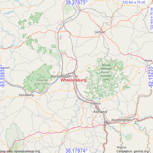
Wheelersburg GPS coordinates[2]
38° 43' 49.26" North, 82° 51' 19.62" West
| Map corner | latitude | longitude |
|---|---|---|
| Upper-left | 39.27675°, | -83.55858° |
| Center: | 38.73035°, | -82.85545° |
| Lower-right: | 38.17974°, | -82.15233° |
| Map W x H: | 122×122 km | = 75.8×75.8mi |
| max Lat: | 71.29058° ⇑57.1% North |
| Wheelersburg: | 38.73035° |
| min Lat: | ⇓42.9% South 19.06759° |
| min Long | Wheelersburg | max Long |
| -171.73463° | -82.85545° | -66.98998° |
| W 62.4%⇐ | ⇒37.6% E |
Elevation
Elevation of Wheelersburg is 168 m = 551 ft, and this is 126.8 m = 416 ft below average elevation for this country.
| Max E: |
3189 m = 10463 ft | 57.5% |
| Avg. | 294.8 m = 967 ft | |
| Wheelersburg | 168 m = 551 ft | |
Min E: |
-60 m = -197 ft | 42.5% |
See also: United States elevation on elevation.city.
Geographical zone
Wheelersburg is located in North temperate zone (between Tropic of Cancer and the Arctic Circle). Distance of this Northern Tropic circle is 1700.5 km =1056.6 mi to South.| Distance of | km | miles | from Wheelersburg |
|---|---|---|---|
| North Pole | 5700.7 | 3542.2 | to North |
| Arctic Circle | 3094.8 | 1923 | to North |
| Tropic Cancer | 1700.5 | 1056.6 | to South |
| Equator | 4306.4 | 2675.9 | to South |


Nearby cities:
15 places around Wheelersburg: (largest is in red/bold)
• Clarktown
14.2 km =8.8 mi,  340°
340°
• Franklin Furnace
9.5 km =5.9 mi,  176°
176°
• Greenup
17.6 km =10.9 mi,  172°
172°
• Lucasville
20.6 km =12.8 mi,  323°
323°
• Minford
14.3 km =8.9 mi,  357°
357°
• New Boston
7.5 km =4.7 mi,  289°
289°
• Portsmouth
12.3 km =7.6 mi,  270°
270°
• Raceland
23.9 km =14.9 mi,  152°
152°
• Rosemount
12.4 km =7.7 mi,  300°
300°
• Sciotodale
3 km =1.9 mi, 336°
• South Shore
9 km =5.6 mi,  263°
263°
• South Webster
14.5 km =9 mi,  50°
50°
• West Portsmouth
15.4 km =9.6 mi,  281°
281°
• Worthington
23.2 km =14.4 mi, 150°
• Wurtland
21.1 km =13.1 mi,  161°
161°
Sources, notices
• [Note1] Compared only with cities in United States existing in our database
• [Src1] Map data: © OpenStreetMap contributors (CC-BY-SA)
• [Src2] Other city data from geonames.org with taken over terms of usage.
• [Src3] Geographical zone / Annual Mean Temperature by Robert A. Rohde @ Wikipedia
