Lahoma geodata
Lahoma (Oklahoma) is a populated place; located in United States in America/Chicago (GMT-5) time zone. With population of 651 people, there are 19169 cities with bigger population in this country. Compared to other cities in United States, 68.5% of cities are located further ↑North; 78.7% of cities are located further →East and 82.9% of cities have lower elevation than Lahoma. Note1


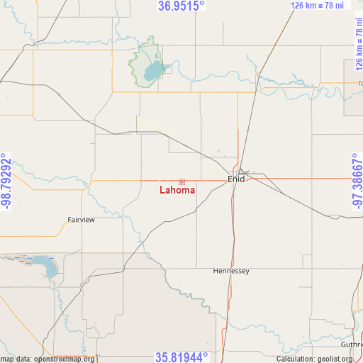
Lahoma GPS coordinates[2]
36° 23' 15.108" North, 98° 5' 23.244" West
| Map corner | latitude | longitude |
|---|---|---|
| Upper-left | 36.9515°, | -98.79292° |
| Center: | 36.38753°, | -98.08979° |
| Lower-right: | 35.81944°, | -97.38667° |
| Map W x H: | 125.9×125.9 km | = 78.2×78.2mi |
| max Lat: | 71.29058° ⇑68.5% North |
| Lahoma: | 36.38753° |
| min Lat: | ⇓31.5% South 19.06759° |
| min Long | Lahoma | max Long |
| -171.73463° | -98.08979° | -66.98998° |
| W 21.3%⇐ | ⇒78.7% E |
Elevation
Elevation of Lahoma is 388 m = 1273 ft, and this is 93.2 m = 306 ft above average elevation for this country.
| Max E: |
3189 m = 10463 ft | 17.1% |
| Lahoma | 388 m 1273 ft | |
| Avg. | 294.8 m = 967 ft | |
Min E: |
-60 m = -197 ft | 82.9% |
See also: United States elevation on elevation.city.
Geographical zone
Lahoma is located in North temperate zone (between Tropic of Cancer and the Arctic Circle). Distance of this Northern Tropic circle is 1440 km =894.8 mi to South.| Distance of | km | miles | from Lahoma |
|---|---|---|---|
| North Pole | 5961.1 | 3704.1 | to North |
| Arctic Circle | 3355.3 | 2084.9 | to North |
| Tropic Cancer | 1440 | 894.8 | to South |
| Equator | 4045.9 | 2514 | to South |


Nearby cities:
15 places around Lahoma: (largest is in red/bold)
• Billings
59.9 km =37.2 mi,  74°
74°
• Canton
58.1 km =36.1 mi,  230°
230°
• Cherokee
47.3 km =29.4 mi,  329°
329°
• Covington
45.9 km =28.5 mi,  101°
101°
• Enid
18.9 km =11.7 mi,  87°
87°
• Fairview
37.3 km =23.2 mi,  249°
249°
• Garber
45.4 km =28.2 mi,  83°
83°
• Helena
23.9 km =14.9 mi,  317°
317°
• Hennessey
35.4 km =22 mi,  151°
151°
• Medford
56.4 km =35 mi,  34°
34°
• North Enid
20.5 km =12.7 mi, 74°
• Okeene
36.4 km =22.6 mi,  214°
214°
• Pond Creek
40.6 km =25.2 mi,  39°
39°
• Ringwood
14 km =8.7 mi,  266°
266°
• Waukomis
20.9 km =13 mi,  124°
124°
Sources, notices
• [Note1] Compared only with cities in United States existing in our database
• [Src1] Map data: © OpenStreetMap contributors (CC-BY-SA)
• [Src2] Other city data from geonames.org with taken over terms of usage.
• [Src3] Geographical zone / Annual Mean Temperature by Robert A. Rohde @ Wikipedia
