Beggs geodata
Beggs (Oklahoma) is a populated place; located in United States in America/Chicago (GMT-5) time zone. With population of 1,247 people, there are 14868 cities with bigger population in this country. Compared to other cities in United States, 71.6% of cities are located further ↑North; 73.6% of cities are located further →East and 57.9% of cities have lower elevation than Beggs. Note1


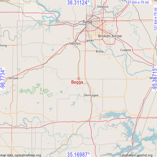
Beggs GPS coordinates[2]
35° 44' 33.36" North, 96° 4' 12.972" West
| Map corner | latitude | longitude |
|---|---|---|
| Upper-left | 36.31124°, | -96.7734° |
| Center: | 35.7426°, | -96.07027° |
| Lower-right: | 35.16987°, | -95.36715° |
| Map W x H: | 126.9×126.9 km | = 78.9×78.9mi |
| max Lat: | 71.29058° ⇑71.6% North |
| Beggs: | 35.7426° |
| min Lat: | ⇓28.4% South 19.06759° |
| min Long | Beggs | max Long |
| -171.73463° | -96.07027° | -66.98998° |
| W 26.4%⇐ | ⇒73.6% E |
Elevation
Elevation of Beggs is 230 m = 755 ft, and this is 64.8 m = 213 ft below average elevation for this country.
| Max E: |
3189 m = 10463 ft | 42.1% |
| Avg. | 294.8 m = 967 ft | |
| Beggs | 230 m = 755 ft | |
Min E: |
-60 m = -197 ft | 57.9% |
See also: United States elevation on elevation.city.
Geographical zone
Beggs is located in North temperate zone (between Tropic of Cancer and the Arctic Circle). Distance of this Northern Tropic circle is 1368.3 km =850.2 mi to South.| Distance of | km | miles | from Beggs |
|---|---|---|---|
| North Pole | 6032.9 | 3748.7 | to North |
| Arctic Circle | 3427 | 2129.4 | to North |
| Tropic Cancer | 1368.3 | 850.2 | to South |
| Equator | 3974.2 | 2469.5 | to South |


Nearby cities:
15 places around Beggs: (largest is in red/bold)
• Bixby
27.9 km =17.3 mi,  37°
37°
• Bristow
30.6 km =19 mi,  288°
288°
• Dewar
33.7 km =20.9 mi,  159°
159°
• Glenpool
24.3 km =15.1 mi,  13°
13°
• Henryetta
34.6 km =21.5 mi,  166°
166°
• Jenks
32.5 km =20.2 mi,  16°
16°
• Kellyville
25.8 km =16 mi,  329°
329°
• Kiefer
22.5 km =14 mi,  1°
1°
• Morris
24.2 km =15 mi,  128°
128°
• Mounds
14.9 km =9.3 mi, 3°
• Okmulgee
16.5 km =10.3 mi,  143°
143°
• Sapulpa
28.7 km =17.8 mi,  352°
352°
• Schulter
27.4 km =17 mi, 157°
• Wilson
26.3 km =16.3 mi, 172°
• Winchester
8.5 km =5.3 mi,  55°
55°
Sources, notices
• [Note1] Compared only with cities in United States existing in our database
• [Src1] Map data: © OpenStreetMap contributors (CC-BY-SA)
• [Src2] Other city data from geonames.org with taken over terms of usage.
• [Src3] Geographical zone / Annual Mean Temperature by Robert A. Rohde @ Wikipedia
