Dewar geodata
Dewar (Oklahoma) is a populated place; located in United States in America/Chicago (GMT-5) time zone. With population of 872 people, there are 17174 cities with bigger population in this country. Compared to other cities in United States, 72.9% of cities are located further ↑North; 73.3% of cities are located further →East and 52.5% of cities have lower elevation than Dewar. Note1


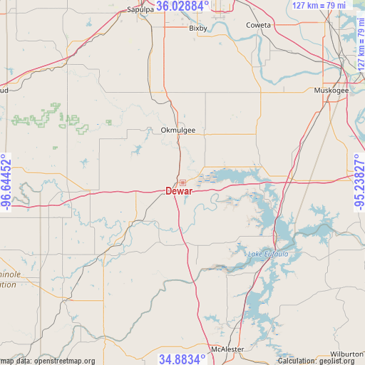
Dewar GPS coordinates[2]
35° 27' 29.376" North, 95° 56' 29.004" West
| Map corner | latitude | longitude |
|---|---|---|
| Upper-left | 36.02884°, | -96.64452° |
| Center: | 35.45816°, | -95.94139° |
| Lower-right: | 34.8834°, | -95.23827° |
| Map W x H: | 127.4×127.4 km | = 79.2×79.2mi |
| max Lat: | 71.29058° ⇑72.9% North |
| Dewar: | 35.45816° |
| min Lat: | ⇓27.1% South 19.06759° |
| min Long | Dewar | max Long |
| -171.73463° | -95.94139° | -66.98998° |
| W 26.7%⇐ | ⇒73.3% E |
Elevation
Elevation of Dewar is 208 m = 682 ft, and this is 86.8 m = 285 ft below average elevation for this country.
| Max E: |
3189 m = 10463 ft | 47.5% |
| Avg. | 294.8 m = 967 ft | |
| Dewar | 208 m = 682 ft | |
Min E: |
-60 m = -197 ft | 52.5% |
See also: United States elevation on elevation.city.
Geographical zone
Dewar is located in North temperate zone (between Tropic of Cancer and the Arctic Circle). Distance of this Northern Tropic circle is 1336.7 km =830.6 mi to South.| Distance of | km | miles | from Dewar |
|---|---|---|---|
| North Pole | 6064.5 | 3768.3 | to North |
| Arctic Circle | 3458.6 | 2149.1 | to North |
| Tropic Cancer | 1336.7 | 830.6 | to South |
| Equator | 3942.6 | 2449.8 | to South |


Nearby cities:
15 places around Dewar: (largest is in red/bold)
• Beggs
33.7 km =20.9 mi,  339°
339°
• Checotah
37.9 km =23.5 mi,  87°
87°
• Eufaula
37.7 km =23.4 mi,  120°
120°
• Haskell
47 km =29.2 mi,  30°
30°
• Henryetta
4.2 km =2.6 mi,  240°
240°
• Longtown
45.5 km =28.3 mi, 121°
• Morris
18.2 km =11.3 mi,  23°
23°
• Okemah
33.1 km =20.6 mi,  265°
265°
• Okmulgee
18.5 km =11.5 mi,  354°
354°
• Schulter
6.4 km =4 mi, 347°
• Texanna
47.4 km =29.5 mi,  105°
105°
• Weleetka
22.3 km =13.9 mi,  232°
232°
• Wetumka
36.6 km =22.7 mi, 227°
• Wilson
10.1 km =6.3 mi,  303°
303°
• Winchester
36.8 km =22.9 mi, 352°
Sources, notices
• [Note1] Compared only with cities in United States existing in our database
• [Src1] Map data: © OpenStreetMap contributors (CC-BY-SA)
• [Src2] Other city data from geonames.org with taken over terms of usage.
• [Src3] Geographical zone / Annual Mean Temperature by Robert A. Rohde @ Wikipedia
