Henryetta geodata
Henryetta (Oklahoma) is a populated place; located in United States in America/Chicago (GMT-5) time zone. With population of 5,765 people, there are 6563 cities with bigger population in this country. Compared to other cities in United States, 73% of cities are located further ↑North; 73.4% of cities are located further →East and 53.2% of cities have lower elevation than Henryetta. Note1


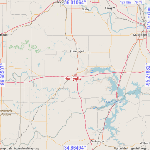
Henryetta GPS coordinates[2]
35° 26' 23.388" North, 95° 58' 54.984" West
| Map corner | latitude | longitude |
|---|---|---|
| Upper-left | 36.01064°, | -96.68507° |
| Center: | 35.43983°, | -95.98194° |
| Lower-right: | 34.86494°, | -95.27882° |
| Map W x H: | 127.4×127.4 km | = 79.2×79.2mi |
| max Lat: | 71.29058° ⇑73% North |
| Henryetta: | 35.43983° |
| min Lat: | ⇓27% South 19.06759° |
| min Long | Henryetta | max Long |
| -171.73463° | -95.98194° | -66.98998° |
| W 26.6%⇐ | ⇒73.4% E |
Elevation
Elevation of Henryetta is 211 m = 692 ft, and this is 83.8 m = 275 ft below average elevation for this country.
| Max E: |
3189 m = 10463 ft | 46.8% |
| Avg. | 294.8 m = 967 ft | |
| Henryetta | 211 m = 692 ft | |
Min E: |
-60 m = -197 ft | 53.2% |
See also: United States elevation on elevation.city.
Geographical zone
Henryetta is located in North temperate zone (between Tropic of Cancer and the Arctic Circle). Distance of this Northern Tropic circle is 1334.6 km =829.3 mi to South.| Distance of | km | miles | from Henryetta |
|---|---|---|---|
| North Pole | 6066.5 | 3769.5 | to North |
| Arctic Circle | 3460.6 | 2150.3 | to North |
| Tropic Cancer | 1334.6 | 829.3 | to South |
| Equator | 3940.5 | 2448.5 | to South |


Nearby cities:
15 places around Henryetta: (largest is in red/bold)
• Beggs
34.6 km =21.5 mi,  346°
346°
• Boley
45.8 km =28.5 mi,  277°
277°
• Checotah
41.7 km =25.9 mi,  85°
85°
• Dewar
4.2 km =2.6 mi,  60°
60°
• Eufaula
40 km =24.9 mi,  115°
115°
• Longtown
47.7 km =29.6 mi, 116°
• Morris
21.7 km =13.5 mi,  30°
30°
• Mounds
49.1 km =30.5 mi, 351°
• Okemah
29.3 km =18.2 mi,  268°
268°
• Okmulgee
20.5 km =12.7 mi,  5°
5°
• Schulter
8.6 km =5.3 mi,  15°
15°
• Weleetka
18.2 km =11.3 mi,  230°
230°
• Wetumka
32.6 km =20.3 mi, 226°
• Wilson
8.9 km =5.5 mi,  327°
327°
• Winchester
38.5 km =23.9 mi,  358°
358°
Sources, notices
• [Note1] Compared only with cities in United States existing in our database
• [Src1] Map data: © OpenStreetMap contributors (CC-BY-SA)
• [Src2] Other city data from geonames.org with taken over terms of usage.
• [Src3] Geographical zone / Annual Mean Temperature by Robert A. Rohde @ Wikipedia
