Okmulgee geodata
Okmulgee (Oklahoma) is a seat of a second-order administrative division; located in United States in America/Chicago (GMT-5) time zone. With population of 12,244 people, there are 3833 cities with bigger population in this country. Compared to other cities in United States, 72.1% of cities are located further ↑North; 73.3% of cities are located further →East and 53.2% of cities have lower elevation than Okmulgee. Note1


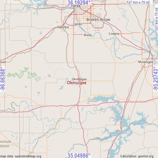
Okmulgee GPS coordinates[2]
35° 37' 24.384" North, 95° 57' 37.98" West
| Map corner | latitude | longitude |
|---|---|---|
| Upper-left | 36.19294°, | -96.66368° |
| Center: | 35.62344°, | -95.96055° |
| Lower-right: | 35.04986°, | -95.25743° |
| Map W x H: | 127.1×127.1 km | = 79×79mi |
| max Lat: | 71.29058° ⇑72.1% North |
| Okmulgee: | 35.62344° |
| min Lat: | ⇓27.9% South 19.06759° |
| min Long | Okmulgee | max Long |
| -171.73463° | -95.96055° | -66.98998° |
| W 26.7%⇐ | ⇒73.3% E |
Elevation
Elevation of Okmulgee is 211 m = 692 ft, and this is 83.8 m = 275 ft below average elevation for this country.
| Max E: |
3189 m = 10463 ft | 46.8% |
| Avg. | 294.8 m = 967 ft | |
| Okmulgee | 211 m = 692 ft | |
Min E: |
-60 m = -197 ft | 53.2% |
See also: United States elevation on elevation.city.
Geographical zone
Okmulgee is located in North temperate zone (between Tropic of Cancer and the Arctic Circle). Distance of this Northern Tropic circle is 1355 km =842 mi to South.| Distance of | km | miles | from Okmulgee |
|---|---|---|---|
| North Pole | 6046.1 | 3756.9 | to North |
| Arctic Circle | 3440.2 | 2137.6 | to North |
| Tropic Cancer | 1355 | 842 | to South |
| Equator | 3961 | 2461.3 | to South |


Nearby cities:
15 places around Okmulgee: (largest is in red/bold)
• Beggs
16.5 km =10.3 mi,  323°
323°
• Bixby
36.1 km =22.4 mi,  11°
11°
• Dewar
18.5 km =11.5 mi,  174°
174°
• Glenpool
37.2 km =23.1 mi,  353°
353°
• Haskell
33.9 km =21.1 mi,  49°
49°
• Henryetta
20.5 km =12.7 mi,  185°
185°
• Kellyville
42.3 km =26.3 mi,  327°
327°
• Kiefer
37 km =23 mi, 345°
• Morris
9.2 km =5.7 mi,  100°
100°
• Mounds
29.6 km =18.4 mi,  342°
342°
• Okemah
37.7 km =23.4 mi,  235°
235°
• Schulter
12.1 km =7.5 mi,  178°
178°
• Weleetka
35.7 km =22.2 mi,  206°
206°
• Wilson
14.5 km =9 mi, 207°
• Winchester
18.3 km =11.4 mi, 351°
Sources, notices
• [Note1] Compared only with cities in United States existing in our database
• [Src1] Map data: © OpenStreetMap contributors (CC-BY-SA)
• [Src2] Other city data from geonames.org with taken over terms of usage.
• [Src3] Geographical zone / Annual Mean Temperature by Robert A. Rohde @ Wikipedia
