Coweta geodata
Coweta (Oklahoma) is a populated place; located in United States in America/Chicago (GMT-5) time zone. With population of 9,559 people, there are 4602 cities with bigger population in this country. Compared to other cities in United States, 70.7% of cities are located further ↑North; 72.7% of cities are located further →East and 51.7% of cities have lower elevation than Coweta. Note1


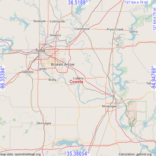
Coweta GPS coordinates[2]
35° 57' 6.372" North, 95° 39' 2.916" West
| Map corner | latitude | longitude |
|---|---|---|
| Upper-left | 36.5189°, | -96.35394° |
| Center: | 35.95177°, | -95.65081° |
| Lower-right: | 35.38054°, | -94.94769° |
| Map W x H: | 126.6×126.6 km | = 78.7×78.7mi |
| max Lat: | 71.29058° ⇑70.7% North |
| Coweta: | 35.95177° |
| min Lat: | ⇓29.3% South 19.06759° |
| min Long | Coweta | max Long |
| -171.73463° | -95.65081° | -66.98998° |
| W 27.3%⇐ | ⇒72.7% E |
Elevation
Elevation of Coweta is 205 m = 673 ft, and this is 89.8 m = 295 ft below average elevation for this country.
| Max E: |
3189 m = 10463 ft | 48.3% |
| Avg. | 294.8 m = 967 ft | |
| Coweta | 205 m = 673 ft | |
Min E: |
-60 m = -197 ft | 51.7% |
See also: United States elevation on elevation.city.
Geographical zone
Coweta is located in North temperate zone (between Tropic of Cancer and the Arctic Circle). Distance of this Northern Tropic circle is 1391.5 km =864.6 mi to South.| Distance of | km | miles | from Coweta |
|---|---|---|---|
| North Pole | 6009.6 | 3734.2 | to North |
| Arctic Circle | 3403.7 | 2115 | to North |
| Tropic Cancer | 1391.5 | 864.6 | to South |
| Equator | 3997.5 | 2483.9 | to South |


Nearby cities:
15 places around Coweta: (largest is in red/bold)
• Bixby
21 km =13 mi,  267°
267°
• Broken Arrow
16.9 km =10.5 mi,  311°
311°
• Catoosa
27.7 km =17.2 mi,  342°
342°
• Glenpool
32.2 km =20 mi, 270°
• Haskell
14.8 km =9.2 mi,  188°
188°
• Inola
25.6 km =15.9 mi,  29°
29°
• Jenks
29.6 km =18.4 mi,  285°
285°
• Kiefer
37.3 km =23.2 mi, 268°
• Muskogee
34 km =21.1 mi,  131°
131°
• New Tulsa
13.9 km =8.6 mi,  351°
351°
• Okay
32 km =19.9 mi,  110°
110°
• Porter
14.6 km =9.1 mi, 127°
• Verdigris
31.7 km =19.7 mi, 353°
• Wagoner
25.3 km =15.7 mi,  88°
88°
• Winchester
35.8 km =22.2 mi,  239°
239°
Sources, notices
• [Note1] Compared only with cities in United States existing in our database
• [Src1] Map data: © OpenStreetMap contributors (CC-BY-SA)
• [Src2] Other city data from geonames.org with taken over terms of usage.
• [Src3] Geographical zone / Annual Mean Temperature by Robert A. Rohde @ Wikipedia
