Porter geodata
Porter (Oklahoma) is a populated place; located in United States in America/Chicago (GMT-5) time zone. With population of 586 people, there are 19856 cities with bigger population in this country. Compared to other cities in United States, 71% of cities are located further ↑North; 72.4% of cities are located further →East and 50.2% of cities have lower elevation than Porter. Note1


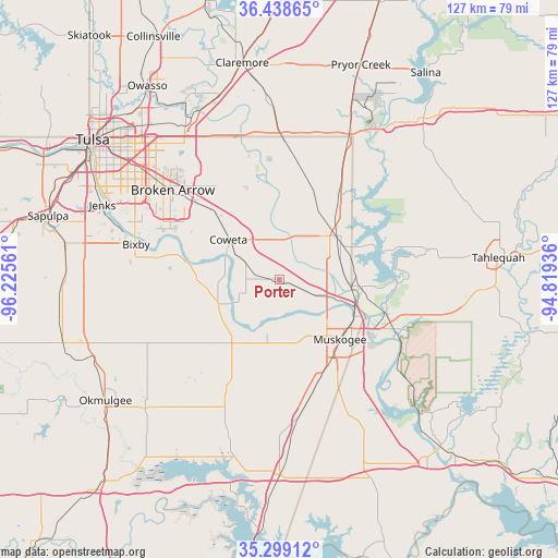
Porter GPS coordinates[2]
35° 52' 15.348" North, 95° 31' 20.928" West
| Map corner | latitude | longitude |
|---|---|---|
| Upper-left | 36.43865°, | -96.22561° |
| Center: | 35.87093°, | -95.52248° |
| Lower-right: | 35.29912°, | -94.81936° |
| Map W x H: | 126.7×126.7 km | = 78.7×78.7mi |
| max Lat: | 71.29058° ⇑71% North |
| Porter: | 35.87093° |
| min Lat: | ⇓29% South 19.06759° |
| min Long | Porter | max Long |
| -171.73463° | -95.52248° | -66.98998° |
| W 27.6%⇐ | ⇒72.4% E |
Elevation
Elevation of Porter is 199 m = 653 ft, and this is 95.8 m = 314 ft below average elevation for this country.
| Max E: |
3189 m = 10463 ft | 49.8% |
| Avg. | 294.8 m = 967 ft | |
| Porter | 199 m = 653 ft | |
Min E: |
-60 m = -197 ft | 50.2% |
See also: United States elevation on elevation.city.
Geographical zone
Porter is located in North temperate zone (between Tropic of Cancer and the Arctic Circle). Distance of this Northern Tropic circle is 1382.6 km =859.1 mi to South.| Distance of | km | miles | from Porter |
|---|---|---|---|
| North Pole | 6018.6 | 3739.8 | to North |
| Arctic Circle | 3412.7 | 2120.6 | to North |
| Tropic Cancer | 1382.6 | 859.1 | to South |
| Equator | 3988.5 | 2478.3 | to South |


Nearby cities:
15 places around Porter: (largest is in red/bold)
• Bixby
33.4 km =20.8 mi,  283°
283°
• Broken Arrow
31.5 km =19.6 mi,  309°
309°
• Catoosa
40.7 km =25.3 mi,  330°
330°
• Chouteau
38.6 km =24 mi,  24°
24°
• Coweta
14.6 km =9.1 mi, 307°
• Fort Gibson
25.8 km =16 mi,  108°
108°
• Haskell
14.8 km =9.2 mi,  247°
247°
• Hulbert
35 km =21.7 mi,  78°
78°
• Inola
31.2 km =19.4 mi,  2°
2°
• Lost City
37.1 km =23.1 mi,  69°
69°
• Muskogee
19.4 km =12.1 mi,  134°
134°
• New Tulsa
26.4 km =16.4 mi, 329°
• Okay
18.5 km =11.5 mi,  96°
96°
• Shady Grove
39.4 km =24.5 mi, 78°
• Wagoner
16.9 km =10.5 mi,  54°
54°
Sources, notices
• [Note1] Compared only with cities in United States existing in our database
• [Src1] Map data: © OpenStreetMap contributors (CC-BY-SA)
• [Src2] Other city data from geonames.org with taken over terms of usage.
• [Src3] Geographical zone / Annual Mean Temperature by Robert A. Rohde @ Wikipedia
