Fairfield geodata
Fairfield (Oklahoma) is a populated place; located in United States in America/Chicago (GMT-5) time zone. With population of 584 people, there are 19867 cities with bigger population in this country. Compared to other cities in United States, 71.1% of cities are located further ↑North; 70.1% of cities are located further →East and 79.9% of cities have lower elevation than Fairfield. Note1


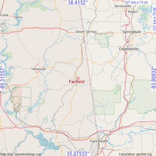
Fairfield GPS coordinates[2]
35° 50' 50.316" North, 94° 36' 44.784" West
| Map corner | latitude | longitude |
|---|---|---|
| Upper-left | 36.4152°, | -95.31557° |
| Center: | 35.84731°, | -94.61244° |
| Lower-right: | 35.27533°, | -93.90932° |
| Map W x H: | 126.7×126.7 km | = 78.7×78.7mi |
| max Lat: | 71.29058° ⇑71.1% North |
| Fairfield: | 35.84731° |
| min Lat: | ⇓28.9% South 19.06759° |
| min Long | Fairfield | max Long |
| -171.73463° | -94.61244° | -66.98998° |
| W 29.9%⇐ | ⇒70.1% E |
Elevation
Elevation of Fairfield is 352 m = 1155 ft, and this is 57.2 m = 188 ft above average elevation for this country.
| Max E: |
3189 m = 10463 ft | 20.1% |
| Fairfield | 352 m 1155 ft | |
| Avg. | 294.8 m = 967 ft | |
Min E: |
-60 m = -197 ft | 79.9% |
See also: United States elevation on elevation.city.
Geographical zone
Fairfield is located in North temperate zone (between Tropic of Cancer and the Arctic Circle). Distance of this Northern Tropic circle is 1379.9 km =857.4 mi to South.| Distance of | km | miles | from Fairfield |
|---|---|---|---|
| North Pole | 6021.2 | 3741.4 | to North |
| Arctic Circle | 3415.3 | 2122.2 | to North |
| Tropic Cancer | 1379.9 | 857.4 | to South |
| Equator | 3985.8 | 2476.7 | to South |


Nearby cities:
15 places around Fairfield: (largest is in red/bold)
• Bell
14.7 km =9.1 mi,  167°
167°
• Brushy
33.9 km =21.1 mi,  197°
197°
• Cedarville
38 km =23.6 mi,  144°
144°
• Cherry Tree
12.1 km =7.5 mi,  193°
193°
• Keys
32.5 km =20.2 mi,  260°
260°
• Lincoln
20.5 km =12.7 mi,  56°
56°
• Park Hill
31.3 km =19.4 mi,  272°
272°
• Pettit
33.1 km =20.6 mi,  253°
253°
• Prairie Grove
30.1 km =18.7 mi, 61°
• Stilwell
3.9 km =2.4 mi, 201°
• Tahlequah
33.1 km =20.6 mi,  283°
283°
• Tenkiller
23.3 km =14.5 mi, 257°
• Welling
26.2 km =16.3 mi, 277°
• West Siloam Springs
36.7 km =22.8 mi,  5°
5°
• Westville
16.6 km =10.3 mi, 13°
Sources, notices
• [Note1] Compared only with cities in United States existing in our database
• [Src1] Map data: © OpenStreetMap contributors (CC-BY-SA)
• [Src2] Other city data from geonames.org with taken over terms of usage.
• [Src3] Geographical zone / Annual Mean Temperature by Robert A. Rohde @ Wikipedia
