Madill geodata
Madill (Oklahoma) is a seat of a second-order administrative division; located in United States in America/Chicago (GMT-5) time zone. With population of 3,923 people, there are 8303 cities with bigger population in this country. Compared to other cities in United States, 79.6% of cities are located further ↑North; 75.1% of cities are located further →East and 61% of cities have lower elevation than Madill. Note1


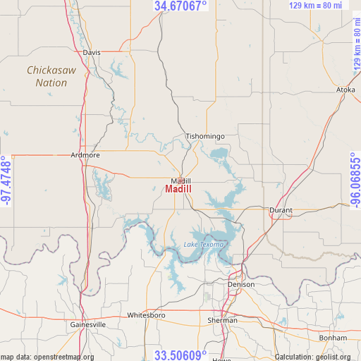
Madill GPS coordinates[2]
34° 5' 25.368" North, 96° 46' 18.012" West
| Map corner | latitude | longitude |
|---|---|---|
| Upper-left | 34.67067°, | -97.4748° |
| Center: | 34.09038°, | -96.77167° |
| Lower-right: | 33.50609°, | -96.06855° |
| Map W x H: | 129.5×129.5 km | = 80.5×80.5mi |
| max Lat: | 71.29058° ⇑79.6% North |
| Madill: | 34.09038° |
| min Lat: | ⇓20.4% South 19.06759° |
| min Long | Madill | max Long |
| -171.73463° | -96.77167° | -66.98998° |
| W 24.9%⇐ | ⇒75.1% E |
Elevation
Elevation of Madill is 244 m = 801 ft, and this is 50.8 m = 167 ft below average elevation for this country.
| Max E: |
3189 m = 10463 ft | 39% |
| Avg. | 294.8 m = 967 ft | |
| Madill | 244 m = 801 ft | |
Min E: |
-60 m = -197 ft | 61% |
See also: United States elevation on elevation.city.
Geographical zone
Madill is located in North temperate zone (between Tropic of Cancer and the Arctic Circle). Distance of this Northern Tropic circle is 1184.6 km =736.1 mi to South.| Distance of | km | miles | from Madill |
|---|---|---|---|
| North Pole | 6216.6 | 3862.8 | to North |
| Arctic Circle | 3610.7 | 2243.6 | to North |
| Tropic Cancer | 1184.6 | 736.1 | to South |
| Equator | 3790.5 | 2355.3 | to South |


Nearby cities:
15 places around Madill: (largest is in red/bold)
• Ardmore
35.5 km =22.1 mi,  285°
285°
• Calera
36.1 km =22.4 mi,  118°
118°
• Cartwright
32.7 km =20.3 mi,  143°
143°
• Colbert
36.2 km =22.5 mi, 136°
• Dickson
22.4 km =13.9 mi,  298°
298°
• Durant
38.5 km =23.9 mi,  106°
106°
• Kingston
11.3 km =7 mi,  154°
154°
• Mannsville
14.6 km =9.1 mi,  316°
316°
• Marietta
36.1 km =22.4 mi,  241°
241°
• Oakland
2.3 km =1.4 mi, 297°
• Pottsboro
38 km =23.6 mi,  165°
165°
• Preston
26.4 km =16.4 mi, 151°
• Ravia
16.9 km =10.5 mi,  6°
6°
• Sherwood Shores
26.8 km =16.7 mi,  189°
189°
• Tishomingo
18.3 km =11.4 mi,  27°
27°
Sources, notices
• [Note1] Compared only with cities in United States existing in our database
• [Src1] Map data: © OpenStreetMap contributors (CC-BY-SA)
• [Src2] Other city data from geonames.org with taken over terms of usage.
• [Src3] Geographical zone / Annual Mean Temperature by Robert A. Rohde @ Wikipedia
