Ravia geodata
Ravia (Oklahoma) is a populated place; located in United States in America/Chicago (GMT-5) time zone. With population of 523 people, there are 20594 cities with bigger population in this country. Compared to other cities in United States, 78.7% of cities are located further ↑North; 75.1% of cities are located further →East and 59.6% of cities have lower elevation than Ravia. Note1


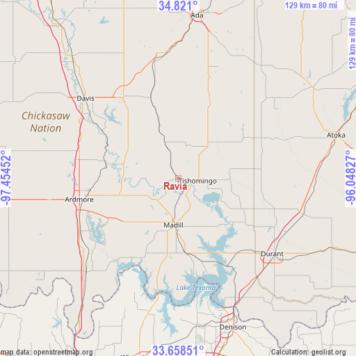
Ravia GPS coordinates[2]
34° 14' 30.336" North, 96° 45' 5.004" West
| Map corner | latitude | longitude |
|---|---|---|
| Upper-left | 34.821°, | -97.45452° |
| Center: | 34.24176°, | -96.75139° |
| Lower-right: | 33.65851°, | -96.04827° |
| Map W x H: | 129.3×129.3 km | = 80.3×80.3mi |
| max Lat: | 71.29058° ⇑78.7% North |
| Ravia: | 34.24176° |
| min Lat: | ⇓21.3% South 19.06759° |
| min Long | Ravia | max Long |
| -171.73463° | -96.75139° | -66.98998° |
| W 24.9%⇐ | ⇒75.1% E |
Elevation
Elevation of Ravia is 238 m = 781 ft, and this is 56.8 m = 186 ft below average elevation for this country.
| Max E: |
3189 m = 10463 ft | 40.4% |
| Avg. | 294.8 m = 967 ft | |
| Ravia | 238 m = 781 ft | |
Min E: |
-60 m = -197 ft | 59.6% |
See also: United States elevation on elevation.city.
Geographical zone
Ravia is located in North temperate zone (between Tropic of Cancer and the Arctic Circle). Distance of this Northern Tropic circle is 1201.4 km =746.5 mi to South.| Distance of | km | miles | from Ravia |
|---|---|---|---|
| North Pole | 6199.7 | 3852.3 | to North |
| Arctic Circle | 3593.8 | 2233.1 | to North |
| Tropic Cancer | 1201.4 | 746.5 | to South |
| Equator | 3807.3 | 2365.7 | to South |


Nearby cities:
15 places around Ravia: (largest is in red/bold)
• Ardmore
36.8 km =22.9 mi,  258°
258°
• Calera
45.3 km =28.1 mi,  138°
138°
• Davis
44.7 km =27.8 mi,  310°
310°
• Dickson
22.3 km =13.9 mi,  254°
254°
• Durant
44.6 km =27.7 mi,  128°
128°
• Kingston
27.2 km =16.9 mi,  173°
173°
• Madill
16.9 km =10.5 mi,  186°
186°
• Mannsville
13.4 km =8.3 mi,  242°
242°
• Oakland
16.2 km =10.1 mi, 193°
• Preston
41.4 km =25.7 mi,  164°
164°
• Roff
43.7 km =27.2 mi,  349°
349°
• Sherwood Shores
43.7 km =27.2 mi, 188°
• Springer
36.9 km =22.9 mi,  282°
282°
• Sulphur
35.7 km =22.2 mi,  326°
326°
• Tishomingo
6.7 km =4.2 mi,  95°
95°
Sources, notices
• [Note1] Compared only with cities in United States existing in our database
• [Src1] Map data: © OpenStreetMap contributors (CC-BY-SA)
• [Src2] Other city data from geonames.org with taken over terms of usage.
• [Src3] Geographical zone / Annual Mean Temperature by Robert A. Rohde @ Wikipedia
