Preston geodata
Preston (Texas) is a populated place; located in United States in America/Chicago (GMT-5) time zone. With population of 2,096 people, there are 11630 cities with bigger population in this country. Compared to other cities in United States, 81.1% of cities are located further ↑North; 74.8% of cities are located further →East and 53.7% of cities have lower elevation than Preston. Note1


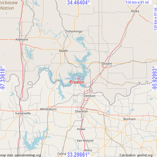
Preston GPS coordinates[2]
33° 52' 56.352" North, 96° 37' 58.98" West
| Map corner | latitude | longitude |
|---|---|---|
| Upper-left | 34.46404°, | -97.33618° |
| Center: | 33.88232°, | -96.63305° |
| Lower-right: | 33.29661°, | -95.92993° |
| Map W x H: | 129.8×129.8 km | = 80.7×80.7mi |
| max Lat: | 71.29058° ⇑81.1% North |
| Preston: | 33.88232° |
| min Lat: | ⇓18.9% South 19.06759° |
| min Long | Preston | max Long |
| -171.73463° | -96.63305° | -66.98998° |
| W 25.2%⇐ | ⇒74.8% E |
Elevation
Elevation of Preston is 213 m = 699 ft, and this is 81.8 m = 268 ft below average elevation for this country.
| Max E: |
3189 m = 10463 ft | 46.3% |
| Avg. | 294.8 m = 967 ft | |
| Preston | 213 m = 699 ft | |
Min E: |
-60 m = -197 ft | 53.7% |
See also: United States elevation on elevation.city.
Geographical zone
Preston is located in North temperate zone (between Tropic of Cancer and the Arctic Circle). Distance of this Northern Tropic circle is 1161.4 km =721.7 mi to South.| Distance of | km | miles | from Preston |
|---|---|---|---|
| North Pole | 6239.7 | 3877.2 | to North |
| Arctic Circle | 3633.8 | 2257.9 | to North |
| Tropic Cancer | 1161.4 | 721.7 | to South |
| Equator | 3767.4 | 2341 | to South |


Nearby cities:
15 places around Preston: (largest is in red/bold)
• Achille
23.3 km =14.5 mi,  103°
103°
• Calera
19.7 km =12.2 mi,  72°
72°
• Cartwright
7.3 km =4.5 mi,  116°
116°
• Colbert
12.5 km =7.8 mi,  105°
105°
• Denison
16.7 km =10.4 mi,  147°
147°
• Durant
27.2 km =16.9 mi,  62°
62°
• Kingston
15.2 km =9.4 mi,  328°
328°
• Luella
35.6 km =22.1 mi,  167°
167°
• Madill
26.4 km =16.4 mi, 331°
• Oakland
28.4 km =17.6 mi, 328°
• Pottsboro
14.1 km =8.8 mi,  193°
193°
• Sherman
27.5 km =17.1 mi,  175°
175°
• Sherwood Shores
17.4 km =10.8 mi,  258°
258°
• Southmayd
30.7 km =19.1 mi,  204°
204°
• Whitesboro
35.7 km =22.2 mi,  225°
225°
Sources, notices
• [Note1] Compared only with cities in United States existing in our database
• [Src1] Map data: © OpenStreetMap contributors (CC-BY-SA)
• [Src2] Other city data from geonames.org with taken over terms of usage.
• [Src3] Geographical zone / Annual Mean Temperature by Robert A. Rohde @ Wikipedia
