Hennessey geodata
Hennessey (Oklahoma) is a populated place; located in United States in America/Chicago (GMT-5) time zone. With population of 2,199 people, there are 11346 cities with bigger population in this country. Compared to other cities in United States, 69.9% of cities are located further ↑North; 78.2% of cities are located further →East and 80.6% of cities have lower elevation than Hennessey. Note1


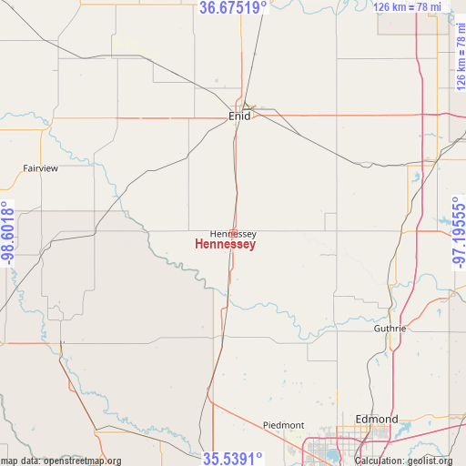
Hennessey GPS coordinates[2]
36° 6' 33.12" North, 97° 53' 55.212" West
| Map corner | latitude | longitude |
|---|---|---|
| Upper-left | 36.67519°, | -98.6018° |
| Center: | 36.1092°, | -97.89867° |
| Lower-right: | 35.5391°, | -97.19555° |
| Map W x H: | 126.3×126.3 km | = 78.5×78.5mi |
| max Lat: | 71.29058° ⇑69.9% North |
| Hennessey: | 36.1092° |
| min Lat: | ⇓30.1% South 19.06759° |
| min Long | Hennessey | max Long |
| -171.73463° | -97.89867° | -66.98998° |
| W 21.8%⇐ | ⇒78.2% E |
Elevation
Elevation of Hennessey is 360 m = 1181 ft, and this is 65.2 m = 214 ft above average elevation for this country.
| Max E: |
3189 m = 10463 ft | 19.4% |
| Hennessey | 360 m 1181 ft | |
| Avg. | 294.8 m = 967 ft | |
Min E: |
-60 m = -197 ft | 80.6% |
See also: United States elevation on elevation.city.
Geographical zone
Hennessey is located in North temperate zone (between Tropic of Cancer and the Arctic Circle). Distance of this Northern Tropic circle is 1409 km =875.5 mi to South.| Distance of | km | miles | from Hennessey |
|---|---|---|---|
| North Pole | 5992.1 | 3723.3 | to North |
| Arctic Circle | 3386.2 | 2104.1 | to North |
| Tropic Cancer | 1409 | 875.5 | to South |
| Equator | 4015 | 2494.8 | to South |


Nearby cities:
15 places around Hennessey: (largest is in red/bold)
• Cashion
39.9 km =24.8 mi,  150°
150°
• Covington
35.7 km =22.2 mi,  51°
51°
• Crescent
32.4 km =20.1 mi,  122°
122°
• Enid
31.9 km =19.8 mi,  3°
3°
• Garber
46 km =28.6 mi,  37°
37°
• Guthrie
49.7 km =30.9 mi, 121°
• Kingfisher
27.7 km =17.2 mi,  186°
186°
• Lahoma
35.4 km =22 mi,  331°
331°
• North Enid
36.4 km =22.6 mi, 4°
• Okarche
43.2 km =26.8 mi, 189°
• Okeene
37.6 km =23.4 mi,  271°
271°
• Piedmont
53.7 km =33.4 mi,  165°
165°
• Ringwood
43.2 km =26.8 mi,  314°
314°
• Watonga
54.8 km =34.1 mi,  237°
237°
• Waukomis
19 km =11.8 mi, 0°
Sources, notices
• [Note1] Compared only with cities in United States existing in our database
• [Src1] Map data: © OpenStreetMap contributors (CC-BY-SA)
• [Src2] Other city data from geonames.org with taken over terms of usage.
• [Src3] Geographical zone / Annual Mean Temperature by Robert A. Rohde @ Wikipedia
