Sulphur geodata
Sulphur (Oklahoma) is a seat of a second-order administrative division; located in United States in America/Chicago (GMT-5) time zone. With population of 5,097 people, there are 7077 cities with bigger population in this country. Compared to other cities in United States, 77.6% of cities are located further ↑North; 75.6% of cities are located further →East and 74% of cities have lower elevation than Sulphur. Note1


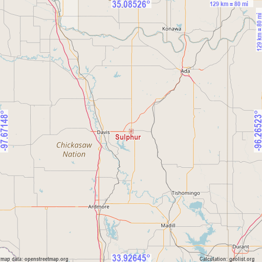
Sulphur GPS coordinates[2]
34° 30' 28.332" North, 96° 58' 6.06" West
| Map corner | latitude | longitude |
|---|---|---|
| Upper-left | 35.08526°, | -97.67148° |
| Center: | 34.50787°, | -96.96835° |
| Lower-right: | 33.92645°, | -96.26523° |
| Map W x H: | 128.8×128.8 km | = 80×80mi |
| max Lat: | 71.29058° ⇑77.6% North |
| Sulphur: | 34.50787° |
| min Lat: | ⇓22.4% South 19.06759° |
| min Long | Sulphur | max Long |
| -171.73463° | -96.96835° | -66.98998° |
| W 24.4%⇐ | ⇒75.6% E |
Elevation
Elevation of Sulphur is 307 m = 1007 ft, and this is 12.2 m = 40 ft above average elevation for this country.
| Max E: |
3189 m = 10463 ft | 26% |
| Sulphur | 307 m 1007 ft | |
| Avg. | 294.8 m = 967 ft | |
Min E: |
-60 m = -197 ft | 74% |
See also: United States elevation on elevation.city.
Geographical zone
Sulphur is located in North temperate zone (between Tropic of Cancer and the Arctic Circle). Distance of this Northern Tropic circle is 1231 km =764.9 mi to South.| Distance of | km | miles | from Sulphur |
|---|---|---|---|
| North Pole | 6170.1 | 3833.9 | to North |
| Arctic Circle | 3564.3 | 2214.8 | to North |
| Tropic Cancer | 1231 | 764.9 | to South |
| Equator | 3836.9 | 2384.1 | to South |


Nearby cities:
15 places around Sulphur: (largest is in red/bold)
• Ada
39.8 km =24.7 mi,  41°
41°
• Ardmore
40.4 km =25.1 mi,  203°
203°
• Davis
13.9 km =8.6 mi,  268°
268°
• Dickson
35.7 km =22.2 mi,  182°
182°
• Elmore City
41.2 km =25.6 mi,  288°
288°
• Lone Grove
45.8 km =28.5 mi,  216°
216°
• Mannsville
36.7 km =22.8 mi,  167°
167°
• Paoli
44.3 km =27.5 mi,  323°
323°
• Pauls Valley
34.7 km =21.6 mi, 318°
• Ravia
35.7 km =22.2 mi,  146°
146°
• Roff
17.7 km =11 mi, 41°
• Springer
26.8 km =16.7 mi, 216°
• Stratford
32.1 km =19.9 mi,  1°
1°
• Tishomingo
40.2 km =25 mi,  138°
138°
• Wynnewood
23.4 km =14.5 mi,  310°
310°
Sources, notices
• [Note1] Compared only with cities in United States existing in our database
• [Src1] Map data: © OpenStreetMap contributors (CC-BY-SA)
• [Src2] Other city data from geonames.org with taken over terms of usage.
• [Src3] Geographical zone / Annual Mean Temperature by Robert A. Rohde @ Wikipedia
