Lawton geodata
Lawton (Oklahoma) is a seat of a second-order administrative division; located in United States in America/Chicago (GMT-5) time zone. With population of 96,655 people, there are 368 cities with bigger population in this country. Compared to other cities in United States, 77.2% of cities are located further ↑North; 79.2% of cities are located further →East and 78.7% of cities have lower elevation than Lawton. Note1


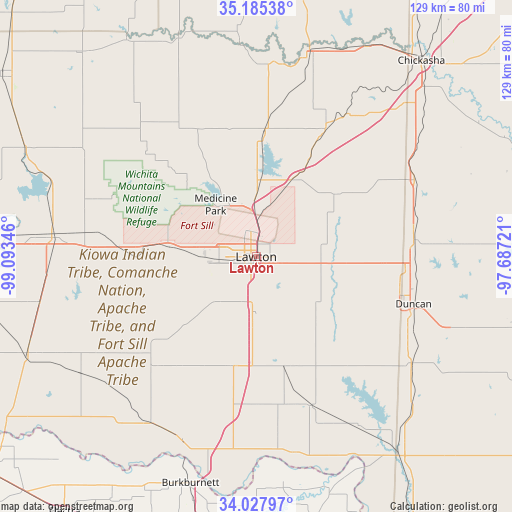
Lawton GPS coordinates[2]
34° 36' 31.284" North, 98° 23' 25.188" West
| Map corner | latitude | longitude |
|---|---|---|
| Upper-left | 35.18538°, | -99.09346° |
| Center: | 34.60869°, | -98.39033° |
| Lower-right: | 34.02797°, | -97.68721° |
| Map W x H: | 128.7×128.7 km | = 80×80mi |
| max Lat: | 71.29058° ⇑77.2% North |
| Lawton: | 34.60869° |
| min Lat: | ⇓22.8% South 19.06759° |
| min Long | Lawton | max Long |
| -171.73463° | -98.39033° | -66.98998° |
| W 20.8%⇐ | ⇒79.2% E |
Elevation
Elevation of Lawton is 342 m = 1122 ft, and this is 47.2 m = 155 ft above average elevation for this country.
| Max E: |
3189 m = 10463 ft | 21.3% |
| Lawton | 342 m 1122 ft | |
| Avg. | 294.8 m = 967 ft | |
Min E: |
-60 m = -197 ft | 78.7% |
See also: Lawton elevation on elevation.city.
Geographical zone
Lawton is located in North temperate zone (between Tropic of Cancer and the Arctic Circle). Distance of this Northern Tropic circle is 1242.2 km =771.9 mi to South.| Distance of | km | miles | from Lawton |
|---|---|---|---|
| North Pole | 6158.9 | 3827 | to North |
| Arctic Circle | 3553 | 2207.7 | to North |
| Tropic Cancer | 1242.2 | 771.9 | to South |
| Equator | 3848.1 | 2391.1 | to South |


Nearby cities:
15 places around Lawton: (largest is in red/bold)
• Apache
31.8 km =19.8 mi,  4°
4°
• Cache
21.9 km =13.6 mi,  276°
276°
• Central High
27.6 km =17.1 mi,  86°
86°
• Cyril
36.4 km =22.6 mi,  28°
28°
• Duncan
41.3 km =25.7 mi,  106°
106°
• Elgin
21.1 km =13.1 mi, 25°
• Empire City
39.3 km =24.4 mi,  122°
122°
• Fletcher
27.3 km =17 mi, 29°
• Geronimo
14.2 km =8.8 mi,  177°
177°
• Marlow
39.8 km =24.7 mi,  83°
83°
• Marlow
39.8 km =24.7 mi, 92°
• Meridian
42.8 km =26.6 mi, 118°
• Sterling
25.4 km =15.8 mi,  51°
51°
• Temple
40 km =24.9 mi,  159°
159°
• Walters
28.7 km =17.8 mi, 164°
Sources, notices
• [Note1] Compared only with cities in United States existing in our database
• [Src1] Map data: © OpenStreetMap contributors (CC-BY-SA)
• [Src2] Other city data from geonames.org with taken over terms of usage.
• [Src3] Geographical zone / Annual Mean Temperature by Robert A. Rohde @ Wikipedia
