Grandfield geodata
Grandfield (Oklahoma) is a populated place; located in United States in America/Chicago (GMT-5) time zone. With population of 972 people, there are 16473 cities with bigger population in this country. Compared to other cities in United States, 78.8% of cities are located further ↑North; 79.6% of cities are located further →East and 79.7% of cities have lower elevation than Grandfield. Note1


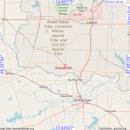
Grandfield GPS coordinates[2]
34° 13' 42.312" North, 98° 41' 4.236" West
| Map corner | latitude | longitude |
|---|---|---|
| Upper-left | 34.80775°, | -99.38764° |
| Center: | 34.22842°, | -98.68451° |
| Lower-right: | 33.64507°, | -97.98139° |
| Map W x H: | 129.3×129.3 km | = 80.3×80.3mi |
| max Lat: | 71.29058° ⇑78.8% North |
| Grandfield: | 34.22842° |
| min Lat: | ⇓21.2% South 19.06759° |
| min Long | Grandfield | max Long |
| -171.73463° | -98.68451° | -66.98998° |
| W 20.4%⇐ | ⇒79.6% E |
Elevation
Elevation of Grandfield is 350 m = 1148 ft, and this is 55.2 m = 181 ft above average elevation for this country.
| Max E: |
3189 m = 10463 ft | 20.3% |
| Grandfield | 350 m 1148 ft | |
| Avg. | 294.8 m = 967 ft | |
Min E: |
-60 m = -197 ft | 79.7% |
See also: United States elevation on elevation.city.
Geographical zone
Grandfield is located in North temperate zone (between Tropic of Cancer and the Arctic Circle). Distance of this Northern Tropic circle is 1199.9 km =745.6 mi to South.| Distance of | km | miles | from Grandfield |
|---|---|---|---|
| North Pole | 6201.2 | 3853.2 | to North |
| Arctic Circle | 3595.3 | 2234 | to North |
| Tropic Cancer | 1199.9 | 745.6 | to South |
| Equator | 3805.8 | 2364.8 | to South |


Nearby cities:
15 places around Grandfield: (largest is in red/bold)
• Burkburnett
17.9 km =11.1 mi,  144°
144°
• Cache
44.9 km =27.9 mi,  6°
6°
• Electra
30.9 km =19.2 mi,  224°
224°
• Frederick
35.7 km =22.2 mi,  300°
300°
• Geronimo
39.4 km =24.5 mi,  44°
44°
• Holliday
45.8 km =28.5 mi,  181°
181°
• Iowa Park
30.8 km =19.1 mi, 177°
• Lakeside City
46.3 km =28.8 mi,  163°
163°
• Lawton
50.2 km =31.2 mi,  32°
32°
• Petrolia
48 km =29.8 mi,  119°
119°
• Snyder
53.8 km =33.4 mi,  332°
332°
• Temple
41.5 km =25.8 mi,  83°
83°
• Tipton
51.8 km =32.2 mi,  306°
306°
• Walters
37.6 km =23.4 mi,  67°
67°
• Wichita Falls
39.2 km =24.4 mi,  153°
153°
Sources, notices
• [Note1] Compared only with cities in United States existing in our database
• [Src1] Map data: © OpenStreetMap contributors (CC-BY-SA)
• [Src2] Other city data from geonames.org with taken over terms of usage.
• [Src3] Geographical zone / Annual Mean Temperature by Robert A. Rohde @ Wikipedia
