Verden geodata
Verden (Oklahoma) is a populated place; located in United States in America/Chicago (GMT-5) time zone. With population of 532 people, there are 20473 cities with bigger population in this country. Compared to other cities in United States, 74.9% of cities are located further ↑North; 78.7% of cities are located further →East and 79.9% of cities have lower elevation than Verden. Note1


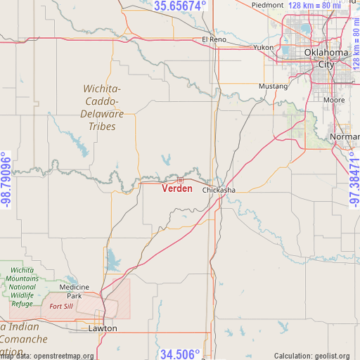
Verden GPS coordinates[2]
35° 5' 0.24" North, 98° 5' 16.188" West
| Map corner | latitude | longitude |
|---|---|---|
| Upper-left | 35.65674°, | -98.79096° |
| Center: | 35.0834°, | -98.08783° |
| Lower-right: | 34.506°, | -97.38471° |
| Map W x H: | 128×128 km | = 79.5×79.5mi |
| max Lat: | 71.29058° ⇑74.9% North |
| Verden: | 35.0834° |
| min Lat: | ⇓25.1% South 19.06759° |
| min Long | Verden | max Long |
| -171.73463° | -98.08783° | -66.98998° |
| W 21.3%⇐ | ⇒78.7% E |
Elevation
Elevation of Verden is 352 m = 1155 ft, and this is 57.2 m = 188 ft above average elevation for this country.
| Max E: |
3189 m = 10463 ft | 20.1% |
| Verden | 352 m 1155 ft | |
| Avg. | 294.8 m = 967 ft | |
Min E: |
-60 m = -197 ft | 79.9% |
See also: United States elevation on elevation.city.
Geographical zone
Verden is located in North temperate zone (between Tropic of Cancer and the Arctic Circle). Distance of this Northern Tropic circle is 1295 km =804.7 mi to South.| Distance of | km | miles | from Verden |
|---|---|---|---|
| North Pole | 6106.2 | 3794.2 | to North |
| Arctic Circle | 3500.3 | 2175 | to North |
| Tropic Cancer | 1295 | 804.7 | to South |
| Equator | 3900.9 | 2423.9 | to South |


Nearby cities:
15 places around Verden: (largest is in red/bold)
• Alex
33.8 km =21 mi,  123°
123°
• Anadarko
14.2 km =8.8 mi,  265°
265°
• Apache
33 km =20.5 mi,  230°
230°
• Binger
34.1 km =21.2 mi,  317°
317°
• Chickasha
14.2 km =8.8 mi,  103°
103°
• Cyril
23.2 km =14.4 mi,  206°
206°
• Elgin
38.5 km =23.9 mi, 208°
• Fletcher
32.3 km =20.1 mi, 206°
• Fort Cobb
31.7 km =19.7 mi, 272°
• Minco
28.6 km =17.8 mi,  27°
27°
• Ninnekah
21.2 km =13.2 mi,  135°
135°
• Rush Springs
35.5 km =22.1 mi,  160°
160°
• Sterling
37.8 km =23.5 mi,  191°
191°
• Tuttle
34 km =21.1 mi,  47°
47°
• Union City
36.8 km =22.9 mi,  21°
21°
Sources, notices
• [Note1] Compared only with cities in United States existing in our database
• [Src1] Map data: © OpenStreetMap contributors (CC-BY-SA)
• [Src2] Other city data from geonames.org with taken over terms of usage.
• [Src3] Geographical zone / Annual Mean Temperature by Robert A. Rohde @ Wikipedia
