Wellston geodata
Wellston (Oklahoma) is a populated place; located in United States in America/Chicago (GMT-5) time zone. With population of 795 people, there are 17856 cities with bigger population in this country. Compared to other cities in United States, 71.8% of cities are located further ↑North; 75.9% of cities are located further →East and 68.9% of cities have lower elevation than Wellston. Note1


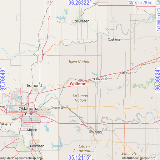
Wellston GPS coordinates[2]
35° 41' 39.228" North, 97° 3' 48.096" West
| Map corner | latitude | longitude |
|---|---|---|
| Upper-left | 36.26322°, | -97.76649° |
| Center: | 35.69423°, | -97.06336° |
| Lower-right: | 35.12115°, | -96.36024° |
| Map W x H: | 127×127 km | = 78.9×78.9mi |
| max Lat: | 71.29058° ⇑71.8% North |
| Wellston: | 35.69423° |
| min Lat: | ⇓28.2% South 19.06759° |
| min Long | Wellston | max Long |
| -171.73463° | -97.06336° | -66.98998° |
| W 24.1%⇐ | ⇒75.9% E |
Elevation
Elevation of Wellston is 280 m = 919 ft, and this is 14.8 m = 49 ft below average elevation for this country.
| Max E: |
3189 m = 10463 ft | 31.1% |
| Avg. | 294.8 m = 967 ft | |
| Wellston | 280 m = 919 ft | |
Min E: |
-60 m = -197 ft | 68.9% |
See also: United States elevation on elevation.city.
Geographical zone
Wellston is located in North temperate zone (between Tropic of Cancer and the Arctic Circle). Distance of this Northern Tropic circle is 1362.9 km =846.9 mi to South.| Distance of | km | miles | from Wellston |
|---|---|---|---|
| North Pole | 6038.2 | 3752 | to North |
| Arctic Circle | 3432.3 | 2132.7 | to North |
| Tropic Cancer | 1362.9 | 846.9 | to South |
| Equator | 3968.8 | 2466.1 | to South |


Nearby cities:
15 places around Wellston: (largest is in red/bold)
• Carney
13.5 km =8.4 mi,  19°
19°
• Chandler
16.5 km =10.3 mi,  87°
87°
• Choctaw
28.7 km =17.8 mi,  220°
220°
• Davenport
26.9 km =16.7 mi, 87°
• Harrah
24.5 km =15.2 mi,  201°
201°
• Jones
24.7 km =15.3 mi,  234°
234°
• Langston
32.8 km =20.4 mi,  328°
328°
• Luther
12.5 km =7.8 mi,  253°
253°
• McLoud
28.8 km =17.9 mi,  185°
185°
• Meeker
25.7 km =16 mi,  145°
145°
• Nicoma Park
32.6 km =20.3 mi, 226°
• Perkins
31.2 km =19.4 mi,  4°
4°
• Spencer
34.2 km =21.3 mi,  236°
236°
• Stroud
37.1 km =23.1 mi,  80°
80°
• Tryon
21.5 km =13.4 mi, 24°
Sources, notices
• [Note1] Compared only with cities in United States existing in our database
• [Src1] Map data: © OpenStreetMap contributors (CC-BY-SA)
• [Src2] Other city data from geonames.org with taken over terms of usage.
• [Src3] Geographical zone / Annual Mean Temperature by Robert A. Rohde @ Wikipedia
