Chandler geodata
Chandler (Oklahoma) is a seat of a second-order administrative division; located in United States in America/Chicago (GMT-5) time zone. With population of 3,175 people, there are 9344 cities with bigger population in this country. Compared to other cities in United States, 71.8% of cities are located further ↑North; 75.4% of cities are located further →East and 70.6% of cities have lower elevation than Chandler. Note1


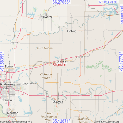
Chandler GPS coordinates[2]
35° 42' 6.228" North, 96° 52' 51.096" West
| Map corner | latitude | longitude |
|---|---|---|
| Upper-left | 36.27066°, | -97.58399° |
| Center: | 35.70173°, | -96.88086° |
| Lower-right: | 35.12871°, | -96.17774° |
| Map W x H: | 127×127 km | = 78.9×78.9mi |
| max Lat: | 71.29058° ⇑71.8% North |
| Chandler: | 35.70173° |
| min Lat: | ⇓28.2% South 19.06759° |
| min Long | Chandler | max Long |
| -171.73463° | -96.88086° | -66.98998° |
| W 24.6%⇐ | ⇒75.4% E |
Elevation
Elevation of Chandler is 289 m = 948 ft, and this is 5.8 m = 19 ft below average elevation for this country.
| Max E: |
3189 m = 10463 ft | 29.4% |
| Avg. | 294.8 m = 967 ft | |
| Chandler | 289 m = 948 ft | |
Min E: |
-60 m = -197 ft | 70.6% |
See also: United States elevation on elevation.city.
Geographical zone
Chandler is located in North temperate zone (between Tropic of Cancer and the Arctic Circle). Distance of this Northern Tropic circle is 1363.7 km =847.4 mi to South.| Distance of | km | miles | from Chandler |
|---|---|---|---|
| North Pole | 6037.4 | 3751.5 | to North |
| Arctic Circle | 3431.5 | 2132.2 | to North |
| Tropic Cancer | 1363.7 | 847.4 | to South |
| Equator | 3969.7 | 2466.7 | to South |


Nearby cities:
15 places around Chandler: (largest is in red/bold)
• Carney
16.8 km =10.4 mi,  314°
314°
• Cushing
33.1 km =20.6 mi,  18°
18°
• Davenport
10.4 km =6.5 mi,  88°
88°
• Drumright
40.6 km =25.2 mi,  38°
38°
• Harrah
34.8 km =21.6 mi,  227°
227°
• Jones
39.7 km =24.7 mi,  247°
247°
• Luther
28.8 km =17.9 mi,  261°
261°
• McLoud
35.2 km =21.9 mi,  212°
212°
• Meeker
22.1 km =13.7 mi,  185°
185°
• Perkins
33.3 km =20.7 mi,  335°
335°
• Prague
29.7 km =18.5 mi,  143°
143°
• Shawnee
41.8 km =26 mi, 185°
• Stroud
20.8 km =12.9 mi,  75°
75°
• Tryon
20.1 km =12.5 mi, 338°
• Wellston
16.5 km =10.3 mi,  267°
267°
Sources, notices
• [Note1] Compared only with cities in United States existing in our database
• [Src1] Map data: © OpenStreetMap contributors (CC-BY-SA)
• [Src2] Other city data from geonames.org with taken over terms of usage.
• [Src3] Geographical zone / Annual Mean Temperature by Robert A. Rohde @ Wikipedia
