McLoud geodata
McLoud (Oklahoma) is a populated place; located in United States in America/Chicago (GMT-5) time zone. With population of 4,615 people, there are 7527 cities with bigger population in this country. Compared to other cities in United States, 73% of cities are located further ↑North; 76% of cities are located further →East and 78.2% of cities have lower elevation than McLoud. Note1


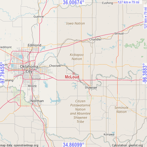
McLoud GPS coordinates[2]
35° 26' 9.24" North, 97° 5' 29.112" West
| Map corner | latitude | longitude |
|---|---|---|
| Upper-left | 36.00674°, | -97.79455° |
| Center: | 35.4359°, | -97.09142° |
| Lower-right: | 34.86099°, | -96.3883° |
| Map W x H: | 127.4×127.4 km | = 79.2×79.2mi |
| max Lat: | 71.29058° ⇑73% North |
| McLoud: | 35.4359° |
| min Lat: | ⇓27% South 19.06759° |
| min Long | McLoud | max Long |
| -171.73463° | -97.09142° | -66.98998° |
| W 24%⇐ | ⇒76% E |
Elevation
Elevation of McLoud is 337 m = 1106 ft, and this is 42.2 m = 138 ft above average elevation for this country.
| Max E: |
3189 m = 10463 ft | 21.8% |
| McLoud | 337 m 1106 ft | |
| Avg. | 294.8 m = 967 ft | |
Min E: |
-60 m = -197 ft | 78.2% |
See also: United States elevation on elevation.city.
Geographical zone
McLoud is located in North temperate zone (between Tropic of Cancer and the Arctic Circle). Distance of this Northern Tropic circle is 1334.2 km =829 mi to South.| Distance of | km | miles | from McLoud |
|---|---|---|---|
| North Pole | 6067 | 3769.9 | to North |
| Arctic Circle | 3461.1 | 2150.6 | to North |
| Tropic Cancer | 1334.2 | 829 | to South |
| Equator | 3940.1 | 2448.3 | to South |


Nearby cities:
15 places around McLoud: (largest is in red/bold)
• Bethel Acres
15.4 km =9.6 mi,  157°
157°
• Choctaw
17.5 km =10.9 mi,  293°
293°
• Del City
31.7 km =19.7 mi,  271°
271°
• Earlsboro
32.1 km =19.9 mi,  125°
125°
• Harrah
8.8 km =5.5 mi,  312°
312°
• Jones
22.9 km =14.2 mi, 309°
• Luther
26.8 km =16.7 mi,  339°
339°
• Meeker
18.7 km =11.6 mi,  66°
66°
• Midwest City
27.7 km =17.2 mi, 273°
• Nicoma Park
21.9 km =13.6 mi, 286°
• Pink
19.7 km =12.2 mi,  187°
187°
• Shawnee
19.3 km =12 mi, 128°
• Spencer
27.6 km =17.1 mi, 290°
• Tecumseh
24.3 km =15.1 mi,  144°
144°
• Wellston
28.8 km =17.9 mi,  5°
5°
Sources, notices
• [Note1] Compared only with cities in United States existing in our database
• [Src1] Map data: © OpenStreetMap contributors (CC-BY-SA)
• [Src2] Other city data from geonames.org with taken over terms of usage.
• [Src3] Geographical zone / Annual Mean Temperature by Robert A. Rohde @ Wikipedia
