Reno geodata
Reno (Texas) is a populated place; located in United States in America/Chicago (GMT-5) time zone. With population of 3,281 people, there are 9179 cities with bigger population in this country. Compared to other cities in United States, 82.3% of cities are located further ↑North; 72.3% of cities are located further →East and 56.2% of cities have higher elevation than Reno. Note1


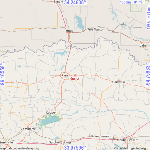
Reno GPS coordinates[2]
33° 39' 47.376" North, 95° 27' 44.82" West
| Map corner | latitude | longitude |
|---|---|---|
| Upper-left | 34.24638°, | -96.16558° |
| Center: | 33.66316°, | -95.46245° |
| Lower-right: | 33.07596°, | -94.75933° |
| Map W x H: | 130.1×130.1 km | = 80.8×80.8mi |
| max Lat: | 71.29058° ⇑82.3% North |
| Reno: | 33.66316° |
| min Lat: | ⇓17.7% South 19.06759° |
| min Long | Reno | max Long |
| -171.73463° | -95.46245° | -66.98998° |
| W 27.7%⇐ | ⇒72.3% E |
Elevation
Elevation of Reno is 175 m = 574 ft, and this is 119.8 m = 393 ft below average elevation for this country.
| Max E: |
3189 m = 10463 ft | 56.2% |
| Avg. | 294.8 m = 967 ft | |
| Reno | 175 m = 574 ft | |
Min E: |
-60 m = -197 ft | 43.8% |
See also: United States elevation on elevation.city.
Geographical zone
Reno is located in North temperate zone (between Tropic of Cancer and the Arctic Circle). Distance of this Northern Tropic circle is 1137.1 km =706.6 mi to South.| Distance of | km | miles | from Reno |
|---|---|---|---|
| North Pole | 6264.1 | 3892.3 | to North |
| Arctic Circle | 3658.2 | 2273.1 | to North |
| Tropic Cancer | 1137.1 | 706.6 | to South |
| Equator | 3743 | 2325.8 | to South |


Nearby cities:
15 places around Reno: (largest is in red/bold)
• Blossom
7.1 km =4.4 mi,  91°
91°
• Bogata
31.4 km =19.5 mi,  132°
132°
• Clarksville
38.4 km =23.9 mi,  98°
98°
• Cooper
38.4 km =23.9 mi,  213°
213°
• Deport
20.4 km =12.7 mi,  138°
138°
• Detroit
18.1 km =11.2 mi, 90°
• Honey Grove
42.4 km =26.3 mi,  257°
257°
• Hugo
38.9 km =24.2 mi,  353°
353°
• Ladonia
52.1 km =32.4 mi,  239°
239°
• Lone Star
15.3 km =9.5 mi,  26°
26°
• Paris
8.6 km =5.3 mi,  268°
268°
• Powderly
17.4 km =10.8 mi,  340°
340°
• Roxton
27.6 km =17.1 mi, 241°
• Talco
47.1 km =29.3 mi, 135°
• Valliant
50.8 km =31.6 mi,  42°
42°
Sources, notices
• [Note1] Compared only with cities in United States existing in our database
• [Src1] Map data: © OpenStreetMap contributors (CC-BY-SA)
• [Src2] Other city data from geonames.org with taken over terms of usage.
• [Src3] Geographical zone / Annual Mean Temperature by Robert A. Rohde @ Wikipedia
