Hugo geodata
Hugo (Oklahoma) is a seat of a second-order administrative division; located in United States in America/Chicago (GMT-5) time zone. With population of 5,224 people, there are 6971 cities with bigger population in this country. Compared to other cities in United States, 80.2% of cities are located further ↑North; 72.4% of cities are located further →East and 57.3% of cities have higher elevation than Hugo. Note1


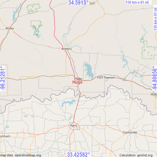
Hugo GPS coordinates[2]
34° 0' 38.376" North, 95° 30' 34.848" West
| Map corner | latitude | longitude |
|---|---|---|
| Upper-left | 34.5915°, | -96.21281° |
| Center: | 34.01066°, | -95.50968° |
| Lower-right: | 33.42582°, | -94.80656° |
| Map W x H: | 129.6×129.6 km | = 80.5×80.5mi |
| max Lat: | 71.29058° ⇑80.2% North |
| Hugo: | 34.01066° |
| min Lat: | ⇓19.8% South 19.06759° |
| min Long | Hugo | max Long |
| -171.73463° | -95.50968° | -66.98998° |
| W 27.6%⇐ | ⇒72.4% E |
Elevation
Elevation of Hugo is 169 m = 554 ft, and this is 125.8 m = 413 ft below average elevation for this country.
| Max E: |
3189 m = 10463 ft | 57.3% |
| Avg. | 294.8 m = 967 ft | |
| Hugo | 169 m = 554 ft | |
Min E: |
-60 m = -197 ft | 42.7% |
See also: United States elevation on elevation.city.
Geographical zone
Hugo is located in North temperate zone (between Tropic of Cancer and the Arctic Circle). Distance of this Northern Tropic circle is 1175.7 km =730.5 mi to South.| Distance of | km | miles | from Hugo |
|---|---|---|---|
| North Pole | 6225.4 | 3868.3 | to North |
| Arctic Circle | 3619.5 | 2249.1 | to North |
| Tropic Cancer | 1175.7 | 730.5 | to South |
| Equator | 3781.6 | 2349.8 | to South |


Nearby cities:
15 places around Hugo: (largest is in red/bold)
• Antlers
26.6 km =16.5 mi,  337°
337°
• Blossom
40.5 km =25.2 mi,  163°
163°
• Bokchito
58.4 km =36.3 mi,  270°
270°
• Boswell
33.2 km =20.6 mi, 273°
• Clarksville
61.3 km =38.1 mi,  136°
136°
• Deport
56.8 km =35.3 mi, 161°
• Detroit
44.8 km =27.8 mi,  149°
149°
• Honey Grove
60.2 km =37.4 mi,  217°
217°
• Lone Star
27.4 km =17 mi, 155°
• Paris
39.1 km =24.3 mi,  186°
186°
• Powderly
22.2 km =13.8 mi,  183°
183°
• Reno
38.9 km =24.2 mi,  173°
173°
• Roxton
55.4 km =34.4 mi,  201°
201°
• Valliant
38.3 km =23.8 mi,  91°
91°
• Wright City
47 km =29.2 mi,  83°
83°
Sources, notices
• [Note1] Compared only with cities in United States existing in our database
• [Src1] Map data: © OpenStreetMap contributors (CC-BY-SA)
• [Src2] Other city data from geonames.org with taken over terms of usage.
• [Src3] Geographical zone / Annual Mean Temperature by Robert A. Rohde @ Wikipedia
